North America before the Canadian Pacific Contract
From the Atlantic Ocean to the Pacific Ocean by RailTrying to understand the continental events preceding the Canadian Pacific Railway Contract
The first regular freight and passenger rail service between the Atlantic Ocean and Pacific Ocean began in ...
A) 1855
B) 1869
C) 1885
D) 1886
B) 1869
C) 1885
D) 1886
Demand for a transcontinental railroad
the US had picked up Texas and the present-day states of Arizona, Utah, Nevada, some other dry bits, and ... best of all ... California.
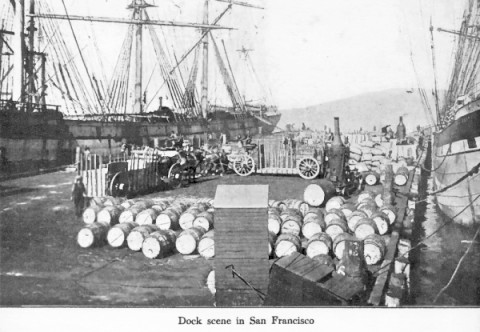
The superb harbour of present-day San Francisco developed into the major centre of the Pacific coast.
Gold, silver and quicksilver (mercury) were discovered farther inland.
There was a big gold rush which helped expand San Francisco and develop the California interior.
You know ... like ... that Miner ... a '49er ... and his daughter ... Clementine.
With a short cut across Central America, the transport distance between New York and San Francisco could be cut by 60%
... rather than sailing around Cape Horn and through the Straits of Magellan.
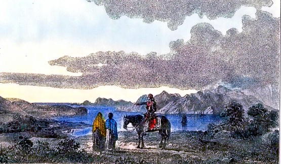
San Francisco harbour ...
before both San Francisco and the harbour - the village people look so lonely.
Since ... oh ... about the days of Columbus, people had been looking for a short cut around the Americas.
Of course, Columbus himself was initially completely ignorant of the continents floating around between Europe ... and the riches of China and India.
OK, so now people were stuck on this Amerigoround trying to get around or through the Americas.
The British explorers of the "Northwest Passage" ... rigidly freezing to death in their wool navy uniforms and stuck in the arctic ice ... were looking for a short cut too.
Getting from Europe to the Far East, particularly for goods uniquely available from China and India, had always been the prize. Navigators were getting tired of having to run around the southern tip of South America (Cape Horn) or southern Africa (Cape of Good Hope).
However, long before Panama canals, it was US citizens themselves who hoped to provide a land bridge over the isthmus of New Granada (today's Columbia + Panama). They wanted to travel over to the west coast of North America using railroad technology - the latest thing. This would make continuous steam transportation between New York and the Pacific Coast possible.
Of course, Columbus himself was initially completely ignorant of the continents floating around between Europe ... and the riches of China and India.
In a geographically
incorrect way, Columbus referred to native Americans as "Indians" by mistake
... but we shall behave like modern Constitutionally-savvy Canadians and call
them "The First Nations" as we go along - even if we happen to refer to the
"Native Americans" of the United States.
OK, so now people were stuck on this Amerigoround trying to get around or through the Americas.
The British explorers of the "Northwest Passage" ... rigidly freezing to death in their wool navy uniforms and stuck in the arctic ice ... were looking for a short cut too.
Getting from Europe to the Far East, particularly for goods uniquely available from China and India, had always been the prize. Navigators were getting tired of having to run around the southern tip of South America (Cape Horn) or southern Africa (Cape of Good Hope).
(The
Suez Canal later provided an alternative to the Cape of Good Hope route
- at least when there were no hostilities around the canal)
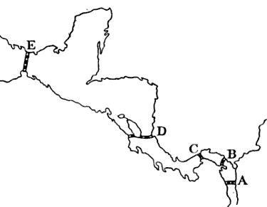
Above are some of the routes for a canal
which were toyed with over decades and centuries. For Route A, they
were going to take ships up the river into South America and then have
a canal-tunnel through the mountains !
To spoil the surprise, Route C and Route D were the only practical alternatives for the large ships of the late 1800s ... and the path to the final choice was pretty twisty.
To spoil the surprise, Route C and Route D were the only practical alternatives for the large ships of the late 1800s ... and the path to the final choice was pretty twisty.
However, long before Panama canals, it was US citizens themselves who hoped to provide a land bridge over the isthmus of New Granada (today's Columbia + Panama). They wanted to travel over to the west coast of North America using railroad technology - the latest thing. This would make continuous steam transportation between New York and the Pacific Coast possible.
Steam was synonymous with ... modern, reliable, orderly, and scheduled.
Steam represented uniformed operators running expensive chugging machines (ships or trains) ...
rather than sailing ships and local people hauling you from point to point with draft animals.
Steam represented uniformed operators running expensive chugging machines (ships or trains) ...
rather than sailing ships and local people hauling you from point to point with draft animals.
I agree it may seem like a cheap trick to consider the Panama Railroad of 1855 a "transcontinental railroad", and it would be possible to make good arguments for any of the dates offered above.
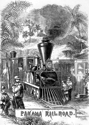
The building of the Panama Railroad was noteworthy.
For example, Chinese workers were later essential in western North American railroad construction. They worked efficiently as self-sufficient work gangs with tremendous mobility from site to site - when compared to workers of European extraction.
Approximately 1000 Chinese workers were brought to Panama to help build the Panama Railroad with their usual supplies of tea, rice and opium. After about a month of work, the "entire body became affected with a melancholic suicidal tendency and scores of them ended their unhappy existence by their own hands" ... then their outlook got worse ... the survivors became sick from the diseases affecting virtually all people working in the isthmus - yellow fever, malaria, typhoid and much much more. A few weeks later only 200 of the Chinese workers were still alive.
The other 6000 workers on hand from India, Ireland, Austria, England, France and Germany were also laid low by tropical diseases and the terrible sanitation of the local settlements. Eventually workers from Jamaica and from neighbouring areas in Central America were found to have the necessary acclimatization to the heat and humidity, and immunity to disease, to perform the construction.
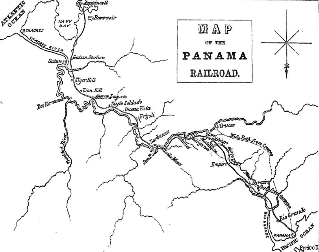
Intuitively, Atlantic to Pacific should be right to left on a standard map - but not with this local geography. I wonder if this is why the cardinal point of the compass (usually north) is pointing south??
In 1855, valuable freight, US and international mail, and people who could pay, wouldn't have to take the scenic routes anymore - but was there much of a demand for this premium 50 mile rail service?
Why yes ! Even before the railroad was complete EVERYONE wanted to get to San Francisco to make their fortune in the Gold Rush. In 1849, the railroad construction was off to a good start on the Atlantic side. So people generally went by train as far as they could and rode the rest of the way on pack mules to the Pacific until the line was finally complete. Mule trails are shown on the map above. Prior to the railway, it took several days to get across to Panama City - often on rough jungle trails with a few nights sleeping in the open on the way.
Pretty soon, the Panama Railroad was working with steamship lines operating on the Atlantic and Pacific - carrying passengers and mail, hauling general freight, and co-ordinating trains with Wells Fargo steamship connections on the 1st 11th and 21st of each month. Wells, Fargo & Company was the FedEx of its day taking gold and silver east, and important legal documents and cash in both directions.
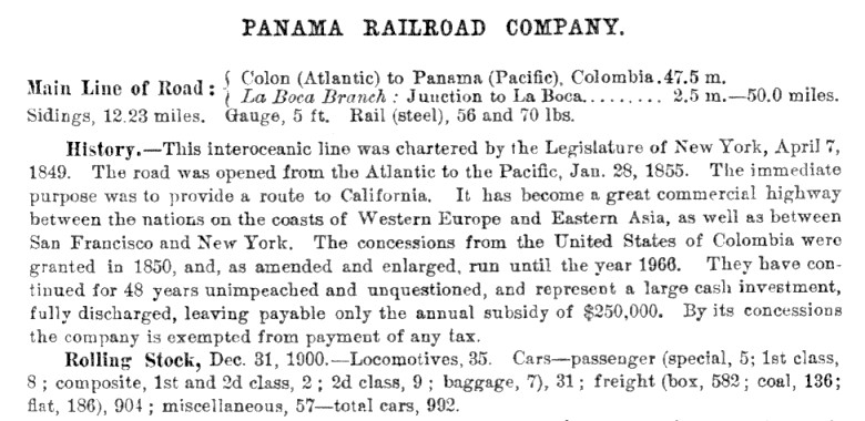
Here is a railroad directory extract about the Panama Railroad with some of its data about 50 years after construction started.
After the gold rush of 1849 things continued on at a good clip until people found other ways to get to San Francisco. The Panama Railroad slowed down, changed hands a couple of times and turned out to be essential in the eventual American Army Corps of Engineers construction of the Panama Canal ... the canal being pretty much along the railroad route you can see in the map above ... "Route C" on that other map which repeats below.
A tenuous connection
I intend to show relevance, Your Honour.
If you will give me some latitude (and some longitude) ... I will, in my own sweet time, show the connections between this little transcontinental and the Canadian Pacific Railway.
First, for example, Your Honour will already know that
By 1889 ... $260,000,000 had been spent and the French canal company went bankrupt with the canal incomplete. Many French investors lost everything in this bankruptcy and there was some fear that the French government would be overthrown. Some accounts say that Baron Jacques de Reinach (the CPR financier) committed suicide in his hotel or was poisoned shortly before his scheduled testimony at the criminal trials and investigation. However, it seems he died of natural causes, as did Count de Lesseps, just a few months later.
Escalating the tragedy is the fact that the French graveyards of Panama from this failure resemble those of the Great War.
1500 to 1700, Common Era
... How to claim a whole continent ...
Step 1 : Go to the eldest male of your kingdom's ruling family - or the eldest female if God has not blessed them with a Male Heir.
Step 2 : Get the monarch of Step 1 to write a note for you on a dried animal skin, using black dye and a bird's feather.
Step 3 : Go to the land area in question, read the note, make a speech in a loud voice, put a pole with colourful embroidery attached into the soil.
Step 4 : Produce a crude map and write a little story about your impressions of this great new land. Go ahead, exaggerate - foreign monarchs will probably still respect your claim.
Next : If you see other Europeans on "your land" ... approach them and determine their ethnicity. If they are subjects of another hereditary monarch ...
Step 1 : Point at the sun for a rough direction reference.
Step 2 : Ask them to observe which way gravity is moving all the loose water molecules ... e.g. "north to this sea", or "south to that gulf". A-ha !
Step 3 : Advise them that your monarch and his/her God has entrusted this land to their representatives : you and your band of soldiers and/or social misfits with swords and primitive firearms.
Step 4 : Kill the trespassers and burn their buildings ( .... or not ... your choice). Optionally, you could subcontract this to your First Nations associates.
This system worked pretty well for a long time because the European hereditary monarchs - for all the misery they caused in the new world - never showed their faces over here ... not one of them !
They also had no apparent interest in making the land claiming system more sophisticated or more expensive to apply.
Changing the rules for claiming the continent
As more and more people started to see the nicer side of life in the new world - particularly in North America - they started building things and making friends with the First Nations people ... well occasionally. Land occupancy and use began to mean more ... than monarchs just swapping crude maps with each other.
Local residents finally had their own local tangible things to fight over - farmland, settlements, mineral resources, river transportation routes.
Way up north, since setting up shop in 1670, the Hudson's Bay Company of London had been been building fur trading posts farther and farther up the northern rivers in their own lethargic way.
Go-getters from Montreal set up the North West Company which became a stable entity in 1787 and sometimes competed with HBC - in HBC's own Royal Charter Hudson Bay watershed area !
Of course there was friction between the British Hudson's Bay monopoly and the North West French-Scottish team. They finally decided to stop fighting and united under the HBC brand in 1821.
Notable during this era were the following explorations (the list is not even close to being all inclusive) :
1731 to 1743 - Pierre Gaultier (La Verendrye) - an officer in the French Colonial Army who sought French support to explore overland for the Pacific. He had to find private financing for the expeditions and ended up exploring much of today's southern Manitoba and Saskatchewan as well as the upper reaches of the Missouri River.
1778 - James Cook - a well-travelled Royal Navy explorer ran up the Pacific Coast, looking for the Northwest Passage from the west.
1792 to 1794 - George Vancouver - another experienced Royal Navy explorer mapped the intricacies of the Pacific coast from California to Alaska, including the continental coast across from ... "Vancouver's Island".
1785 to 1811 - David Thompson - of the HBC was an extraordinary self-taught star shooter, surveyor and cartographer and accurately mapped a huge swath of land between Hudson Bay and the mouth of the Columbia River. Between 1812 and 1814, he produced a map of this area which was the standard relied on for decades.
1789 to 1793 - Alexander Mackenzie, a partner of the North West Company explored the Mackenzie River to the Arctic Ocean and travelled up the Peace River and down the Bella Coola to the Pacific Ocean. Note: Having the First Nations take you for a tour counted as exploration if you did things the right way.
1808 to 1812 and after 1817 when the US Congress prohibited foreign fur companies from operating on US soil ... The first Astor, the German-born John Jacob Astor, ran the Pacific Fur CompanyColumbia River ... and the South West Fur Company (through the purchase of a Canadian enterprise) which operated south of the Great Lakes. However, the HBC's "North West Company acquisition" gave the HBC a significant presence on the Pacific Coast and down along the Columbia River in the area of the present day Washington and Oregon states. American traders had a hard time competing with the well-organized HBC machine and hungry American explorers sometimes couldn't even get help from local First Nations because the latter's bread was buttered by the HBC. which sought to control the fur business on the
Canada still a colony
As I try to weave - or staple gun - this North American continental history together
consider that the northern continental exploration (i.e. in the future western Canada) was dominated by ...
nattily-dressed Royal Navy ship drivers with a tight hold on their dinghies ...
or HBC traders who did deign to grub around on the land - but mainly to make money ... not maps.
These fur traders and their First Nations colleagues travelled all over the land ...
however, except for a little route sketching and a few trading posts, there was little to demonstrate land occupancy.
In fact, the HBC hated colonists because they interfered with their trade.
Colonists thought they could trade for furs themselves ... because they hadn't read the Royal Charter !
The Royal Navy explorers and the HBC lads were controlled from faraway England.
The French had their own problems in Europe and had pretty much forsaken North America years before.
Meanwhile, the US population had grown significantly and had continued to push westward to enjoy all the ex-Canadian topsoil left there by the various glaciations.
The Americans had local control while the "British North America" side had to call home for instructions from the absentee landlords
Britain saw the United States as a powerful peer ... while the people of the Canadas, Rupert's Land, the Canadian northwest, and the Pacific coast were simply subjects in a second-rate colony.
Jefferson sends Lewis and Clark
In 1803, President Thomas Jefferson had a look at the map of the continent ...
As the US continued to expand west - over the territories previously promised to the First Nations (sorry, our bad) - he decided someone should formally study the area into which the US would probably expand next.
Captain Meriwether Lewis, who had been Jefferson's private secretary for a couple of years had asked for the assignment. Jefferson describing Lewis, wrote that he was "of courage undaunted, possessing a firmness and perseverance of purpose which nothing but impossibility could divert from its direction". Lewis, 30, selected a 34 year old friend, William Clark to be the second-in-command of the expedition - and the latter was given the rank of captain to fit the task.
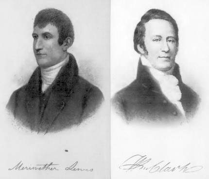
Jefferson wanted them to travel rather quietly so their party was limited to 27 men - about half of them were US soldiers.
Lewis & Martin ... Clark on the road ... on boats, on foot and on horseback.
Boundaries and surveys
The map below shows the "49th parallel" border negotiated between Britain and the US at the Convention of Commerce in 1818.
This covered British North America from Lake of the Woods ... to the Rockies - not to the Pacific Ocean.
The British and Americans agreed to delay negotiation on the Oregon Territory, the south of which was found to be excellent for agriculture and brimming with mineral wealth.
This later resulted in some American advocates demanding the entire coast from latitude 49 N ... up to 54 degrees 40 minutes ... today's Alaska.
But ... today many American newscasters mistakenly believe that most Canadians live "north of the 49th parallel" ... so who knows?
HBC established Victoria in 1843 in case they were cut off from Fort Vancouver ...
and indeed they were, when the 49th parallel was extended to the Pacific Ocean in 1846.
Referring to the decision of the Canadian Pacific Railway in 1881 to build across the southern prairies and through the Kicking Horse Pass nearer to today's Banff ...
rather than the Yellowhead Pass nearer to today's Jasper, Pierre Berton in The Last Spike asks:
A report submitted to the US Senate Committee on Pacific Railroads in February 1869 had stated:
The 91st meridian runs roughly midway between Thunder Bay and Duluth. So according to this thinking, newly-formed Canada would not exist west of the Great Lakes.
Three professional engineers employed by the Northern Pacific Railroad submitted a report to the railroad's president, which was subsequently presented to the Pacific Railroad Committee of Congress in March 1868. They suggested that the US Government could not afford to withhold the "desired aid" to build the railroad. Both of these reports were prepared almost immediately after the "small versions" of early Ontario and Quebec were created as a result of the 1867 Confederation... and as the US recovered from its Civil War.
The Northern Pacific Railroad report includes these estimates of annual revenue:
With Historical Hindsight in 1906
Perhaps the most important reasons for the selecting a southern route for the CPR were :
American Lines
Northern Pacific Railroad - completed 1883 - Dotted line Duluth to Tacoma
Great Northern Railway - Pacific access in 1893 - Solid line Duluth to Seattle
Canadian Lines
Canadian Pacific Railway - completed 1885 - Dotted line north of border.
The Soo Line - running diagonally from 105 degrees W in Canada to St. Paul. Controlled by CPR 1888.
The 'dotted lines' railroads received government aid.
You can bet that eyebrows were raised when Canadian government subsidized CPR began to control the Soo Line to St. Paul ... with control of additional lines to Sault Ste Marie and Chicago.
More than a colonial railway
More than a national railway
- Among other things, one could argue there is a difference between the "final piece of a transcontinental system" and a "coast to coast company".
- But it would probably be more rewarding to contemplate the various reasons for building railroads across vast expanses of land.
The building of the Panama Railroad was noteworthy.
- The Panama road was completed very early in the railway era
- 19 years after the first railway in Canada ... co-incidentally the latter was also a
cute little "portage" railway between navigable waterways.
- The swamps and reptiles, climate, wide and often torrential rushing rivers, and disease-spreading wee beasties were brutal.
For example, Chinese workers were later essential in western North American railroad construction. They worked efficiently as self-sufficient work gangs with tremendous mobility from site to site - when compared to workers of European extraction.
Approximately 1000 Chinese workers were brought to Panama to help build the Panama Railroad with their usual supplies of tea, rice and opium. After about a month of work, the "entire body became affected with a melancholic suicidal tendency and scores of them ended their unhappy existence by their own hands" ... then their outlook got worse ... the survivors became sick from the diseases affecting virtually all people working in the isthmus - yellow fever, malaria, typhoid and much much more. A few weeks later only 200 of the Chinese workers were still alive.
The other 6000 workers on hand from India, Ireland, Austria, England, France and Germany were also laid low by tropical diseases and the terrible sanitation of the local settlements. Eventually workers from Jamaica and from neighbouring areas in Central America were found to have the necessary acclimatization to the heat and humidity, and immunity to disease, to perform the construction.
Like the canal that followed SIXTY years
later (1914), the Panama Railroad ran SOUTH-EAST from Atlantic to Pacific.
Intuitively, Atlantic to Pacific should be right to left on a standard map - but not with this local geography. I wonder if this is why the cardinal point of the compass (usually north) is pointing south??
In 1855, valuable freight, US and international mail, and people who could pay, wouldn't have to take the scenic routes anymore - but was there much of a demand for this premium 50 mile rail service?
Why yes ! Even before the railroad was complete EVERYONE wanted to get to San Francisco to make their fortune in the Gold Rush. In 1849, the railroad construction was off to a good start on the Atlantic side. So people generally went by train as far as they could and rode the rest of the way on pack mules to the Pacific until the line was finally complete. Mule trails are shown on the map above. Prior to the railway, it took several days to get across to Panama City - often on rough jungle trails with a few nights sleeping in the open on the way.
Pretty soon, the Panama Railroad was working with steamship lines operating on the Atlantic and Pacific - carrying passengers and mail, hauling general freight, and co-ordinating trains with Wells Fargo steamship connections on the 1st 11th and 21st of each month. Wells, Fargo & Company was the FedEx of its day taking gold and silver east, and important legal documents and cash in both directions.
Here is a railroad directory extract about the Panama Railroad with some of its data about 50 years after construction started.
After the gold rush of 1849 things continued on at a good clip until people found other ways to get to San Francisco. The Panama Railroad slowed down, changed hands a couple of times and turned out to be essential in the eventual American Army Corps of Engineers construction of the Panama Canal ... the canal being pretty much along the railroad route you can see in the map above ... "Route C" on that other map which repeats below.
A tenuous connection
I intend to show relevance, Your Honour.
If you will give me some latitude (and some longitude) ... I will, in my own sweet time, show the connections between this little transcontinental and the Canadian Pacific Railway.
First, for example, Your Honour will already know that
- the financier known as Baron Joseph 'Jacques' de Reinach of Paris France,
- a member of the first Board of Directors of the Canadian Pacific Railway,
- and whose firm was a party to the Canadian Pacific Railway contract with the Canadian Government,
By 1889 ... $260,000,000 had been spent and the French canal company went bankrupt with the canal incomplete. Many French investors lost everything in this bankruptcy and there was some fear that the French government would be overthrown. Some accounts say that Baron Jacques de Reinach (the CPR financier) committed suicide in his hotel or was poisoned shortly before his scheduled testimony at the criminal trials and investigation. However, it seems he died of natural causes, as did Count de Lesseps, just a few months later.
Escalating the tragedy is the fact that the French graveyards of Panama from this failure resemble those of the Great War.
The Americans, meanwhile, had been
beavering away at Route D using Lake Nicaragua - a nice route. However,
for a discount price and a "deal", they were induced to take over the
French mess at Route C in 1904. The result was The Panama Canal, completed in 1914.
1500 to 1700, Common Era
... How to claim a whole continent ...
Let's face it :
Compared to buying a three bedroom bungalow today ...
standards were pretty lax when it came to Europeans claiming land ...
on any new world continent.
Compared to buying a three bedroom bungalow today ...
standards were pretty lax when it came to Europeans claiming land ...
on any new world continent.
Step 1 : Go to the eldest male of your kingdom's ruling family - or the eldest female if God has not blessed them with a Male Heir.
Step 2 : Get the monarch of Step 1 to write a note for you on a dried animal skin, using black dye and a bird's feather.
Step 3 : Go to the land area in question, read the note, make a speech in a loud voice, put a pole with colourful embroidery attached into the soil.
Step 4 : Produce a crude map and write a little story about your impressions of this great new land. Go ahead, exaggerate - foreign monarchs will probably still respect your claim.
Next : If you see other Europeans on "your land" ... approach them and determine their ethnicity. If they are subjects of another hereditary monarch ...
Step 1 : Point at the sun for a rough direction reference.
Step 2 : Ask them to observe which way gravity is moving all the loose water molecules ... e.g. "north to this sea", or "south to that gulf". A-ha !
Step 3 : Advise them that your monarch and his/her God has entrusted this land to their representatives : you and your band of soldiers and/or social misfits with swords and primitive firearms.
Step 4 : Kill the trespassers and burn their buildings ( .... or not ... your choice). Optionally, you could subcontract this to your First Nations associates.
This system worked pretty well for a long time because the European hereditary monarchs - for all the misery they caused in the new world - never showed their faces over here ... not one of them !
They also had no apparent interest in making the land claiming system more sophisticated or more expensive to apply.
Changing the rules for claiming the continent
As more and more people started to see the nicer side of life in the new world - particularly in North America - they started building things and making friends with the First Nations people ... well occasionally. Land occupancy and use began to mean more ... than monarchs just swapping crude maps with each other.
Local residents finally had their own local tangible things to fight over - farmland, settlements, mineral resources, river transportation routes.
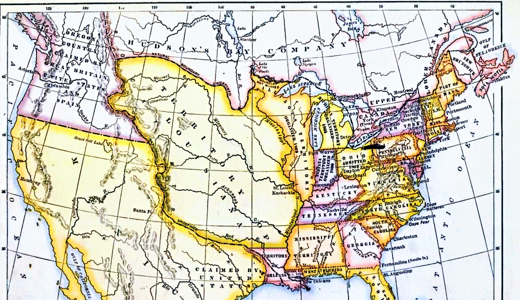
Here
is North America in 1810. The United States of America really like
drawing fancy coloured borders around all the little states, eh?
Way up north, since setting up shop in 1670, the Hudson's Bay Company of London had been been building fur trading posts farther and farther up the northern rivers in their own lethargic way.
Go-getters from Montreal set up the North West Company which became a stable entity in 1787 and sometimes competed with HBC - in HBC's own Royal Charter Hudson Bay watershed area !
The cheeky devils !
Of course there was friction between the British Hudson's Bay monopoly and the North West French-Scottish team. They finally decided to stop fighting and united under the HBC brand in 1821.
Notable during this era were the following explorations (the list is not even close to being all inclusive) :
1731 to 1743 - Pierre Gaultier (La Verendrye) - an officer in the French Colonial Army who sought French support to explore overland for the Pacific. He had to find private financing for the expeditions and ended up exploring much of today's southern Manitoba and Saskatchewan as well as the upper reaches of the Missouri River.
1778 - James Cook - a well-travelled Royal Navy explorer ran up the Pacific Coast, looking for the Northwest Passage from the west.
1792 to 1794 - George Vancouver - another experienced Royal Navy explorer mapped the intricacies of the Pacific coast from California to Alaska, including the continental coast across from ... "Vancouver's Island".
1785 to 1811 - David Thompson - of the HBC was an extraordinary self-taught star shooter, surveyor and cartographer and accurately mapped a huge swath of land between Hudson Bay and the mouth of the Columbia River. Between 1812 and 1814, he produced a map of this area which was the standard relied on for decades.
1789 to 1793 - Alexander Mackenzie, a partner of the North West Company explored the Mackenzie River to the Arctic Ocean and travelled up the Peace River and down the Bella Coola to the Pacific Ocean. Note: Having the First Nations take you for a tour counted as exploration if you did things the right way.
1808 to 1812 and after 1817 when the US Congress prohibited foreign fur companies from operating on US soil ... The first Astor, the German-born John Jacob Astor, ran the Pacific Fur CompanyColumbia River ... and the South West Fur Company (through the purchase of a Canadian enterprise) which operated south of the Great Lakes. However, the HBC's "North West Company acquisition" gave the HBC a significant presence on the Pacific Coast and down along the Columbia River in the area of the present day Washington and Oregon states. American traders had a hard time competing with the well-organized HBC machine and hungry American explorers sometimes couldn't even get help from local First Nations because the latter's bread was buttered by the HBC. which sought to control the fur business on the
Canada still a colony
As I try to weave - or staple gun - this North American continental history together
consider that the northern continental exploration (i.e. in the future western Canada) was dominated by ...
nattily-dressed Royal Navy ship drivers with a tight hold on their dinghies ...
or HBC traders who did deign to grub around on the land - but mainly to make money ... not maps.
These fur traders and their First Nations colleagues travelled all over the land ...
however, except for a little route sketching and a few trading posts, there was little to demonstrate land occupancy.
In fact, the HBC hated colonists because they interfered with their trade.
Colonists thought they could trade for furs themselves ... because they hadn't read the Royal Charter !
The Royal Navy explorers and the HBC lads were controlled from faraway England.
The French had their own problems in Europe and had pretty much forsaken North America years before.
Meanwhile, the US population had grown significantly and had continued to push westward to enjoy all the ex-Canadian topsoil left there by the various glaciations.
The Americans had local control while the "British North America" side had to call home for instructions from the absentee landlords
Britain saw the United States as a powerful peer ... while the people of the Canadas, Rupert's Land, the Canadian northwest, and the Pacific coast were simply subjects in a second-rate colony.
Strangely, it was probably snobbish
stubborn retention of British affectation by anglophone Canadians,
which preserved British North America ...
it certainly wasn't the vigorous protection of Canadian interests by the Colonial Office.
which preserved British North America ...
it certainly wasn't the vigorous protection of Canadian interests by the Colonial Office.
Jefferson sends Lewis and Clark
In 1803, President Thomas Jefferson had a look at the map of the continent ...
As the US continued to expand west - over the territories previously promised to the First Nations (sorry, our bad) - he decided someone should formally study the area into which the US would probably expand next.
Captain Meriwether Lewis, who had been Jefferson's private secretary for a couple of years had asked for the assignment. Jefferson describing Lewis, wrote that he was "of courage undaunted, possessing a firmness and perseverance of purpose which nothing but impossibility could divert from its direction". Lewis, 30, selected a 34 year old friend, William Clark to be the second-in-command of the expedition - and the latter was given the rank of captain to fit the task.
Jefferson wanted them to travel rather quietly so their party was limited to 27 men - about half of them were US soldiers.
"The object of your mission is to
explore the Missouri River, and such principal stream, as by its course
and communication with the waters of the Pacific Ocean, whether the
Columbia, Oregon, Colorado or any other river, may offer the most
direct and practicable water communication across the continent for the
purposes of commerce"
The Columbia and Oregon were different names for the same river, but Jefferson didn't know this.
In April 1803, the French "Louisiana" territory was transferred to the United States.
This is the same map as above ... from 1810
Lewis & Martin ... Clark on the road ... on boats, on foot and on horseback.
- May 1804 - Lewis and Clark set off from a point near St. Louis, later known as "the gateway to the west".
- November 1804 - they prepared to winter on the Missouri near present day Bismarck.
- April 1805 - the journey was resumed with Lewis and Clark dividing the party at times to explore more ground.
- November 1805 - they reached the Pacific Ocean via the Columbia River and spent the winter preparing for the return journey.
- March 1806 - the return trip began with more split-party exploration.
- September 1806 - the reunited party reached St. Louis.
The states shown below and the border with British North American did not exist at the time of Lewis and Clark's expedition.
Eventually some settlers were travelling in by wagon to the Oregon Territory.
In the 1830s some American Protestant missionaries to the First Nations in the Oregon area wrote about the ease of crossing the mountains by wagon ...
and this further supported one of the possible outcomes of the Lewis and Clark Expedition - building a wagon road to facilitate settlement and communication.
Boundaries and surveys
The map below shows the "49th parallel" border negotiated between Britain and the US at the Convention of Commerce in 1818.
This covered British North America from Lake of the Woods ... to the Rockies - not to the Pacific Ocean.
The British and Americans agreed to delay negotiation on the Oregon Territory, the south of which was found to be excellent for agriculture and brimming with mineral wealth.
This later resulted in some American advocates demanding the entire coast from latitude 49 N ... up to 54 degrees 40 minutes ... today's Alaska.
But ... today many American newscasters mistakenly believe that most Canadians live "north of the 49th parallel" ... so who knows?
HBC established Victoria in 1843 in case they were cut off from Fort Vancouver ...
and indeed they were, when the 49th parallel was extended to the Pacific Ocean in 1846.
Mexico had kicked Spain out so the
Spanish influence on the west
coast had diminished. Then the United States fought Mexico and
1845-1848
obtained Texas and what would become the southwestern states.This
provided American politicians with clear title to the land across
the southern part of the United States from Atlantic to Pacific.
There are a number of references to various people advocating an US Pacific railway in the 1830s. Merchant Asa Whitney actually presented plans on how to finance, support and gradually build across the northern states near the 49th Parallel to the mouth of the Columbia. Other Pacific railway advocates were considered to be "wild enthusiasts" or "madmen". (Sadly, today some model railroaders are seen in the same light)
The concept of a Pacific railroad was slow to catch on because at this point, North American railroad technology was rudimentary and frail ... and a railroad's cost to benefit relationship was not clear - particularly to those who believed in governments having a very limited role in the nation's affairs.
The California Gold Rush of 1849 - which brought success to the transcontinental Panama Railroad - finally got Congress to act on an American Pacific railway. In addition to travelling across Panama by rail and around Cape Horn by ship, gold rushers were finding their own routes across the American west, braving hostile First Nations and deserts.
In March 1853 the War Department was directed by Congress to begin explorations and surveys to determine the best route for a railroad between the Mississippi River and the Pacific. To make things kind of simple for this flat-wheeled drag of a webpage - there were finally 13 bound volumes documenting the explorations - three principal routes were surveyed, with variations ...
North Pacific - Lake Superior and the head of navigation of the Mississippi to Puget Sound ... between the 46th and 48th parallels.
Central Pacific - From the Missouri River near Omaha to San Francisco ... between the 41st and 42nd parallels.
South Pacific - From Preston on the Red River in Texas to a point between San Diego and San Francisco ... near the 32nd parallel.
Other variations - Kansas City or Fort Smith to San Francisco or another California harbour - known as the Kansas Pacific route.
Jefferson Davis, a southerner, plantation owner, Mexican War hero and later President of the Southern Confederacy ... was also the Secretary of War in charge of the railroad surveys 1854 to 1857. He really liked the southern route and favoured the 1853 Gadsden Purchase which involved paying Mexico $10 million to ensure the US-Mexico boundary agreement included a southern strip along the south of New Mexico and Arizona ... which would facilitate building the South Pacific railroad route.
The South Pacific route which Davis favoured, would run ocean to ocean, easily serving ports in Texas and New Orleans. It would be shorter and over easier geography and thus less expensive to build. And ... introducing a benefit which doesn't spring to mind instantly for a Canadian Pacific enthusiast... the railroad would not have all the problems of snow shutdowns which the Central and North routes would have !
Action on the US Pacific railroad
Unfortunately, for Davis and the South - and fortunately for the dense railway network and industries of the North - the US Civil War took place between 1861 and 1865. California with gold ; agriculture ; trade with Asia and up the coast to Victoria and beyond ; and Nevada with its silver ... were too good to lose to the Confederacy.
So ... quick as a bunny, Congress chartered the Union Pacific (get it? Union Pacific not Confederate Pacific) in 1862 to send the right signals to the west and construction started west from Omaha in 1865. Simultaneously, the San Francisco merchant-driven Central Pacific Railroad was built east from Sacramento and the lines met in wide open Utah in 1869. The central route between the Mississippi and the Pacific had been chosen as you have concluded.
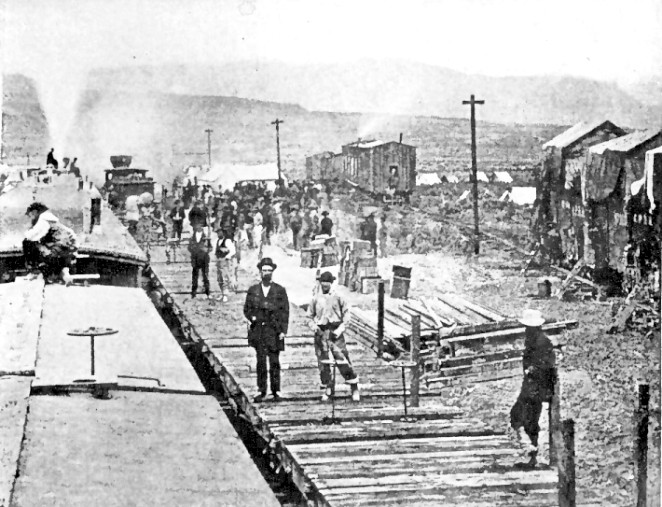
At one of the Central Pacific construction camps as the road was built through California and Nevada.
Accounts tell of bedrolls on top of the over-sized dormitory cars, and hammocks slung beneath.
Many of the workers on the Central/Union Pacific had been in the Civil War,
so they were accustomed to spartan living conditions and regimented labour.
This was easier than the Civil War - only the First Nations warriors were trying to kill you here.
In building the US Pacific railway there were all kinds of problems with First Nations ... who evidently hadn't received the memo about their title to their land being extinguished.
As well, there were all sorts of financial shenanigans. You see, there are people who think you can make a lot of money :
The map below shows the land grants given to the "land grant" incentive railroads. This also shows the Northern, Central/Union and South Pacific routes nicely. Notice the streamers of railways building west from the Mississippi River.
Contemporary transportation and technology in Canada
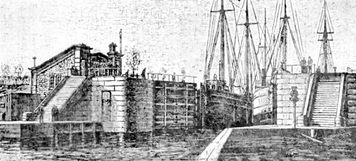
The first Welland Canal - between Lake Ontario and Lake Erie in Canada - was completed in 1829.
Negotiating in 1880 with awareness of recent American experiences
Most of the effort of this page (my writing - your patient reading) is to better understand the historical, political, financial, technological and other conditions existing BEFORE the Government of Canada sat down with the CPR principals to negotiate the Canadian Pacific Railway Contract ... after the Government's own CPR construction had failed.
The Government ; the builders and operators (i.e. the CPR Syndicate) ; and the latter's outside financial backers had to somehow predict and negotiate the terms necessary to ensure a successful railway was built ... and had to strike a balance between excessive profits and bankruptcy for the company. Then the terms had to be presented to Parliament where Macdonald had a majority government ... but the Grits would expose and publicize aspects of the CPR bill which were flawed or might seem excessively generous to the company.
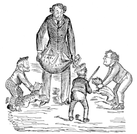
"Waiting for the cat" (1880)
George Brown's Globe newspaper ... and Liberal leader Edward Blake
are ready to review the Syndicate bargain.
Perhaps the stick-holder is The Rt. Hon. Alexander Mackenzie,
the former Liberal Prime Minister of Canada ...
never a big Pacific railway enthusiast himself.
- - -
Here are a few simple examples dealing with the railroad construction conditions :
But you can imagine it was complex and there were sometimes disagreements of interpretation
between the company and the government
as the CPR was being built.
The Mystery of the Canadian Pacific route through the mountains
There are a number of references to various people advocating an US Pacific railway in the 1830s. Merchant Asa Whitney actually presented plans on how to finance, support and gradually build across the northern states near the 49th Parallel to the mouth of the Columbia. Other Pacific railway advocates were considered to be "wild enthusiasts" or "madmen". (Sadly, today some model railroaders are seen in the same light)
The concept of a Pacific railroad was slow to catch on because at this point, North American railroad technology was rudimentary and frail ... and a railroad's cost to benefit relationship was not clear - particularly to those who believed in governments having a very limited role in the nation's affairs.
The California Gold Rush of 1849 - which brought success to the transcontinental Panama Railroad - finally got Congress to act on an American Pacific railway. In addition to travelling across Panama by rail and around Cape Horn by ship, gold rushers were finding their own routes across the American west, braving hostile First Nations and deserts.
In March 1853 the War Department was directed by Congress to begin explorations and surveys to determine the best route for a railroad between the Mississippi River and the Pacific. To make things kind of simple for this flat-wheeled drag of a webpage - there were finally 13 bound volumes documenting the explorations - three principal routes were surveyed, with variations ...
North Pacific - Lake Superior and the head of navigation of the Mississippi to Puget Sound ... between the 46th and 48th parallels.
Central Pacific - From the Missouri River near Omaha to San Francisco ... between the 41st and 42nd parallels.
South Pacific - From Preston on the Red River in Texas to a point between San Diego and San Francisco ... near the 32nd parallel.
Other variations - Kansas City or Fort Smith to San Francisco or another California harbour - known as the Kansas Pacific route.
Jefferson Davis, a southerner, plantation owner, Mexican War hero and later President of the Southern Confederacy ... was also the Secretary of War in charge of the railroad surveys 1854 to 1857. He really liked the southern route and favoured the 1853 Gadsden Purchase which involved paying Mexico $10 million to ensure the US-Mexico boundary agreement included a southern strip along the south of New Mexico and Arizona ... which would facilitate building the South Pacific railroad route.
The South Pacific route which Davis favoured, would run ocean to ocean, easily serving ports in Texas and New Orleans. It would be shorter and over easier geography and thus less expensive to build. And ... introducing a benefit which doesn't spring to mind instantly for a Canadian Pacific enthusiast... the railroad would not have all the problems of snow shutdowns which the Central and North routes would have !
Action on the US Pacific railroad
Unfortunately, for Davis and the South - and fortunately for the dense railway network and industries of the North - the US Civil War took place between 1861 and 1865. California with gold ; agriculture ; trade with Asia and up the coast to Victoria and beyond ; and Nevada with its silver ... were too good to lose to the Confederacy.
So ... quick as a bunny, Congress chartered the Union Pacific (get it? Union Pacific not Confederate Pacific) in 1862 to send the right signals to the west and construction started west from Omaha in 1865. Simultaneously, the San Francisco merchant-driven Central Pacific Railroad was built east from Sacramento and the lines met in wide open Utah in 1869. The central route between the Mississippi and the Pacific had been chosen as you have concluded.
It
was during the American Civil War that the railroad was recognized as a
strategic system for moving troops, weapons and war supplies. A great
art was also made of destroying the enemy's rolling stock and
infrastructure. Not only were piles of torn up rails made unusable by
building
bonfires under them ... the enemy could be taunted by twisting the hot
rails into distinctive shapes, including "Sherman's neckties" around
trees. (US military strategy no longer considered it important to
occupy an enemy's land mass and use its railroads after World War 2)
At one of the Central Pacific construction camps as the road was built through California and Nevada.
Accounts tell of bedrolls on top of the over-sized dormitory cars, and hammocks slung beneath.
Many of the workers on the Central/Union Pacific had been in the Civil War,
so they were accustomed to spartan living conditions and regimented labour.
This was easier than the Civil War - only the First Nations warriors were trying to kill you here.
In building the US Pacific railway there were all kinds of problems with First Nations ... who evidently hadn't received the memo about their title to their land being extinguished.
As well, there were all sorts of financial shenanigans. You see, there are people who think you can make a lot of money :
- In railroad construction - sometimes an inducement to build a shoddy railroad.
- In railroad operation - charging traffic what the market will bear and selling off government railroad land grants (thanks First Nations!).
- Because you have special connections - some of the participants in the Union Pacific and Congress did this, resulting in the Credit Mobilier scandal.
The map below shows the land grants given to the "land grant" incentive railroads. This also shows the Northern, Central/Union and South Pacific routes nicely. Notice the streamers of railways building west from the Mississippi River.
Contemporary transportation and technology in Canada
After the War of 1812-1814,
British military engineers set up a system of canals to provide secure
military transportation between Kingston, at the east end of Lake Ontario, and Montreal. The St. Lawrence
River was the preferred transportation route, but at points of this section it formed the
boundary between British North America and the US - and could easily be cut off
in a war. Although these were not the only canals built during this
period, they were financed by the government because of the possibility
of renewed American attack. Three canals on the Ottawa River were built 1819 to 1834 and the famous Rideau Canal system between Kingston and today's Ottawa was built 1826 to 1834.
The first Welland Canal - between Lake Ontario and Lake Erie in Canada - was completed in 1829.
By the time the American Pacific roads
were being constructed, Canada had a well developed railway network east of the Great Lakes.
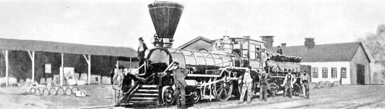
Above is a Grand Trunk wood burning locomotive circa 1860.
Sloppy leisurely posture is often seen in photographs of this era. The workplace usually demanded regular physical labour.
Consequently, back then, a moment of leaning was as chic as ... power-biking to work where one will be slumped at a computer all day.
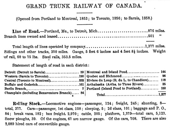
Here is the Grand Trunk Railway's status as it was recorded circa 1874.
Built mainly by British investors, it worked primarily as a city-to-city highway.
The seaport of Portland Maine allowed all-year access to European markets.
Built mainly by British investors, it worked primarily as a city-to-city highway.
The seaport of Portland Maine allowed all-year access to European markets.
Negotiating in 1880 with awareness of recent American experiences
Most of the effort of this page (my writing - your patient reading) is to better understand the historical, political, financial, technological and other conditions existing BEFORE the Government of Canada sat down with the CPR principals to negotiate the Canadian Pacific Railway Contract ... after the Government's own CPR construction had failed.
The Government ; the builders and operators (i.e. the CPR Syndicate) ; and the latter's outside financial backers had to somehow predict and negotiate the terms necessary to ensure a successful railway was built ... and had to strike a balance between excessive profits and bankruptcy for the company. Then the terms had to be presented to Parliament where Macdonald had a majority government ... but the Grits would expose and publicize aspects of the CPR bill which were flawed or might seem excessively generous to the company.
In fact, no one could know what the railway's future would be.
There was no benefit in bankrupting the CPR and having the problem land in the Government's lap again.
Many have argued then and since that the terms were too generous.
Many have argued then and since that the terms were too generous.
"Waiting for the cat" (1880)
George Brown's Globe newspaper ... and Liberal leader Edward Blake
are ready to review the Syndicate bargain.
Perhaps the stick-holder is The Rt. Hon. Alexander Mackenzie,
the former Liberal Prime Minister of Canada ...
never a big Pacific railway enthusiast himself.
- - -
So the negotiators thought of many things, including ...
What aspects of all the Union Pacific processes should be copied ... and which should be avoided ?
What were the political realities and history which were important to the Pacific railway and Canadians ?
What aspects of all the Union Pacific processes should be copied ... and which should be avoided ?
What were the political realities and history which were important to the Pacific railway and Canadians ?
- - -
Here are a few simple examples dealing with the railroad construction conditions :
- The maximum gradient - maximum = 2.2 % and the roadbed grading standard were to be the same as the Union Pacific.
- Land grants would be used in much the same way ... as an incentive for completing sections of the road to specification.
- In both cases it was stated the government would extinguish Indian title to the lands involved. However, in Canada, the NWMP
(our beloved Mounties) helped strip title in a firm disciplined
red-coated way. This Canadian process was helped by the fact ... that
the First Nations in the US had
already experienced the firm, undisciplined
method of land confiscation and word had spread among the First Nations
of what to expect from the "webmaster-faces".
- In Canada, the CPR company being formed would have to both build and later operate the railway - so overcharging for shoddy construction
would not pay off. As the project progressed, unethical or incompetent subcontractors would be in receipt of a
memorandum signed by William Van Horne's or Collingwood Schreiber's boot.
- For now, we'll skip comparing ...
- Financing payments ("gifts") by government of government
bonds and cash.
- Mortgage bonds issued on the completed road.
- Second
government mortgage on the road.
- Land bonds issued on the earned land grants.
- Land or cash being held in trust by the government.
- Who held which class of common stock with which voting rights.
- And many other financial instruments and corporate structuring techniques used to lure private investor capital to build the Union Pacific and the Canadian Pacific.
But you can imagine it was complex and there were sometimes disagreements of interpretation
between the company and the government
as the CPR was being built.
The Mystery of the Canadian Pacific route through the mountains
Referring to the decision of the Canadian Pacific Railway in 1881 to build across the southern prairies and through the Kicking Horse Pass nearer to today's Banff ...
rather than the Yellowhead Pass nearer to today's Jasper, Pierre Berton in The Last Spike asks:
Why were they all so eager to push their railroad through unknown country? Why did they give up [Sandford]
Fleming's careful location in favour of a hazardous route across two
mountain ramparts whose passes had not yet been surveyed or even
explored? If the Kicking Horse were chosen it would mean that every
pound of freight carried across the mountains would have to be hoisted
an additional sixteen hundred feet higher into the clouds.
A report submitted to the US Senate Committee on Pacific Railroads in February 1869 had stated:
The
line of the North Pacific road runs for 1,500 miles near the British
possessions, and, when built, will drain the agricultural products of
the rich Saskatchewan and Red River districts east of the mountains,
and the gold country on the Fraser, Thompson, and Kootanie [sic] rivers
west of the mountains. From China (Canton) to Liverpool it is 1,500
miles nearer by the 49th parallel of latitude than by the way of San
Francisco and New York. This advantage, in securing the overland trade
from Asia, will not be thrown away by the English, unless it is taken
away by our first building the North Pacific road, establishing
mercantile agencies at Puget Sound, fixing mercantile capital there,
and getting possession, on land and the ocean, of all the machinery of
the new commerce between Asia and Europe. The opening by us first of a
North Pacific railroad seals the destiny of the British possessions
west of the 91st meridian. They will become so Americanised in
interests and feeling that they will be in effect severed from the new
Dominion, and the question of their annexation will be but a question
of time.
The 91st meridian runs roughly midway between Thunder Bay and Duluth. So according to this thinking, newly-formed Canada would not exist west of the Great Lakes.
Three professional engineers employed by the Northern Pacific Railroad submitted a report to the railroad's president, which was subsequently presented to the Pacific Railroad Committee of Congress in March 1868. They suggested that the US Government could not afford to withhold the "desired aid" to build the railroad. Both of these reports were prepared almost immediately after the "small versions" of early Ontario and Quebec were created as a result of the 1867 Confederation... and as the US recovered from its Civil War.
Can
Government afford to maintain a comparatively inefficient military
establishment in our Indian country and on a frontier line, at such
vast labor and expense? Can it afford in these days of railroads and
telegraphs, to disseminate intelligence by the slow process of the mail
coach and horse-back rider? Can it afford to permit millions on
millions of acres of its most fertile lands to lie waste and
unproductive, to be roamed over by savages, instead of being converted
into cultivated fields and made the homes of prosperous citizens? ...
Time is material. The territory to be developed lies upon the frontier. Contiguous to it, over the border, is also a territory containing some 500,000 square miles, possessing more than two thousand miles of lakes and rivers which are navigable by steam, and capable of sustaining a population of twenty millions; possessing a climate, soil, and mineral wealth scarcely less desirable and valuable than our own. This country is now sparsely inhabited by a people having their principal commercial and social relations on our side of the border. These people naturally gravitate to us. The construction of our road, at once, would secure their trade and friendship in the future. By delay that friendship and trade may be lost.
Already the project of constructing a Pacific Railroad on British soil, north of our border, is matter of serious consideration. Influential parties from Canada are now understood to be in England to urge upon the British Government the necessity of granting a liberal subsidy for the construction of this road. It will constitute an extension of the Inter-Colonial Railroad, which has already received the aid of the Imperial Government, and form a link in the great contemplated line which is intended to span the continent, and bind together, as it were in chains of iron, the different British provinces on this continent, and form a great channel of commerce between Europe and Asia. The construction of such a road would exclude from us the business of that great territory, and the wealth consequent thereon, and preclude the idea of political relations between that people and our own.
The Northern Pacific Railroad report includes these estimates of annual revenue:
Estimate of Revenue
Express - United States, Canada, Europe, and Asia $ 700,000
US Mail, Canadian, European, and Asiatic Mails $ 500,000
Transportation for Posts of Hudson Bay Company $1,000,000
There is no amount given for the Canadian share of general freight and passenger business - total $21,000,000
Express - United States, Canada, Europe, and Asia $ 700,000
US Mail, Canadian, European, and Asiatic Mails $ 500,000
Transportation for Posts of Hudson Bay Company $1,000,000
There is no amount given for the Canadian share of general freight and passenger business - total $21,000,000
With Historical Hindsight in 1906
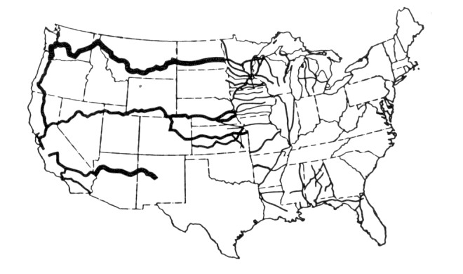
- Below are the western main lines - only - of the transcontinental railroads running near the Canadian border in 1906.
- Their locations and dates of completion help explain the importance of the Canadian Pacific Railway to the political and commercial viability of Canada west of Lake Superior.
- A special 20 year monopoly clause (relinquished after 10 years) in the CPR contract helped keep most railways from building anything between the CPR line and the border.
- A more northern route through today's Saskatoon, Edmonton and Jasper would have lowered the CPR's operating costs.
Perhaps the most important reasons for the selecting a southern route for the CPR were :
- Confronting possible incursions by US railroads ...
- Constructing a quick direct route to facilitate commerce and travel between the Far East, Eastern North America and Europe.
American Lines
Northern Pacific Railroad - completed 1883 - Dotted line Duluth to Tacoma
Great Northern Railway - Pacific access in 1893 - Solid line Duluth to Seattle
Canadian Lines
Canadian Pacific Railway - completed 1885 - Dotted line north of border.
The Soo Line - running diagonally from 105 degrees W in Canada to St. Paul. Controlled by CPR 1888.
The 'dotted lines' railroads received government aid.
You can bet that eyebrows were raised when Canadian government subsidized CPR began to control the Soo Line to St. Paul ... with control of additional lines to Sault Ste Marie and Chicago.
More than a colonial railway
More than a national railway
Commenting on this CPR ship (6000 tons, 16 knots) which was in service as the CPR was completed ...
When
the new 18 knot 15,000 ton steamers are afloat, they will cross the
Pacific in eight days ; they will carry 200 first, 100 second, and 800
third class passengers ; and with new steamers also on the Atlantic,
people will be able to travel from Liverpool to Yokohama in 17 days.
While
the American railroads were often operating in prosperous areas
demanding high levels of freight and passenger service, they were
primarily continental and even semi-continental enterprises. The
barrier of the Mississippi River and the course of American history had stopped
the fluid extension of railroad systems from the south and east into "The
West". The abundance of American investment capital looking for industrial
investments helped
reinforce this national focus. (In 1921, for example, railroad securities constituted 50.7% of the par value of all securities at the New York Stock Exchange)
With many of the Canadian Pacific's principals and political patrons being "foreigners" who knew the world outside Canada, the company developed more along the lines of a modern multinational corporation. A multinational having continental, British Empire and world-wide perspectives. One intended function of the CPR main line - similar to the Panama Railroad - was to act as a land bridge between the company's own steamship routes.
With the help of Pierre Berton's narrative, we can admire the CPR as a plucky little national system triumphing over forbidding geography, political enemies, and predictions of failure.
However, for reasons of devotion to the British Empire and resistance against America's manifest destiny to dominate the continent ... the sense of achievement from building something great and using money to help keep score ... the work ethic that "there will be sleeping enough in the grave" ... a degree of personal vanity in some cases ... and a determination that failure at anything could not be permitted ... the men driven to create the Canadian Pacific Railway considered factors beyond operating through the "best" farmland and over the "easiest" mountain grades.
In
the decades which followed, the Canadian Pacific's southern route choice did
demand expensive rebuilding in places and did result in higher operating costs.
However, its builders saw the world beyond Canada's borders and they located their line accordingly.
However, its builders saw the world beyond Canada's borders and they located their line accordingly.