Quebec Railway Postcards
Quebec Railway Light & Power Company, Carillon and Grenville Railway,
Le chemin de fer de colonisation du Nord, Montfort and Gatineau Colonization Railway Company
... and other Quebec longname shortlines.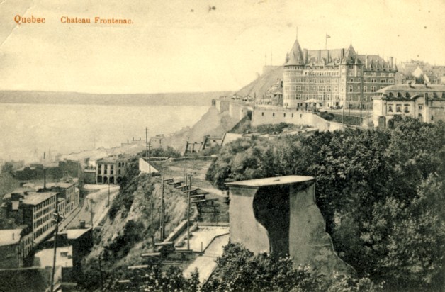
Mailed from Quebec to Copper Cliff, Ontario in June 1912, this postcard shows an early version of the CPR Chateau Frontenac ...
" I leave to-morrow for a 6 months trip on the 'Arctic' - to Baffin Land, Hudson Bay '& other points'.
Goodbye and good luck. WBW "
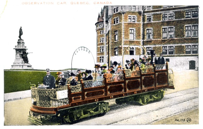
The white sign by the motorman reads "Seeing Quebec".
It should read: "Fashion rides the rails!"
The letterboard displays "QRL&P Co".
These tourists likely arrived in Quebec City by rail ... and are departing the Chateau Frontenac for a scenic tour.
These open streetcars operated in many cities for sightseeing. A number still operate at museums.
The Quebec Railway Light &
Power Company combined the assets of Quebec City's street railway ; a
short steam railway operating east from Quebec City along the north
shore of the St. Lawrence River ; and a power generating station operating at Montmorency Falls.
Beginning in 1900, steam gave way to electricity ... with electrification completed east to Saint Joachim. Heavy, coach-like interurban cars served 46 stops along the 25 miles of track.
Beginning in 1900, steam gave way to electricity ... with electrification completed east to Saint Joachim. Heavy, coach-like interurban cars served 46 stops along the 25 miles of track.
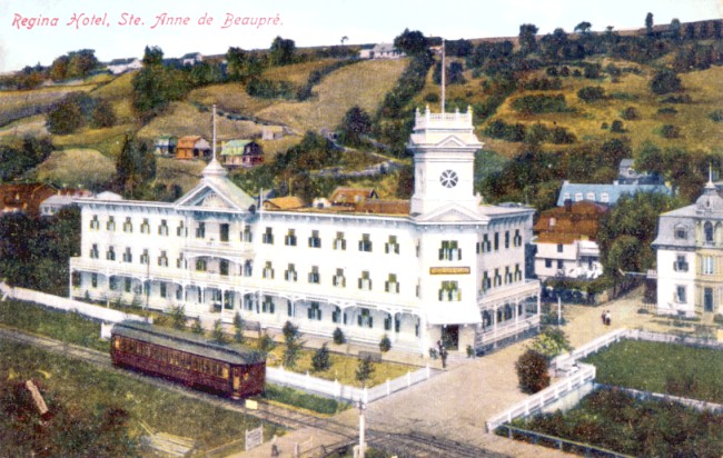
QRL&P interurban car at Ste Anne de Beaupré
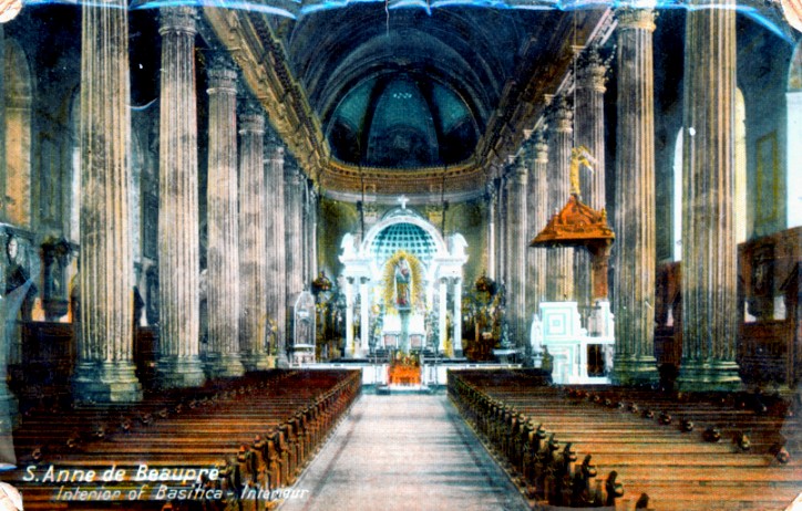
A significant amount of passenger traffic came from pilgrimages to the shrine at Ste. Anne de Beaupré.
A church had stood there since 1658 and Pope Leon XIII designated the
rebuilt church a basilica in 1887. In the early 1900s between 1
million and 2 million people used the line per year.
The local passenger service's end coincided with the popularity of the automobile. CNR bought the electrified line in 1951 and the remaining local passenger traffic was carried by buses beginning in 1959.
The local passenger service's end coincided with the popularity of the automobile. CNR bought the electrified line in 1951 and the remaining local passenger traffic was carried by buses beginning in 1959.
It seems that most people in eastern North America
would know of someone who had once visited Ste. Anne de Beaupré in years past.
This card was written and mailed by an adult to St. Louis, Missouri in July 1911.
" ... With love from your godson ... "
and signed in script by the child.
Probably derived from the Great War British Army 'field service postcard' is this Montreal souvenir.
Field service postcards helped soldiers to communicate (serious) standardized personal news
from the trenches without a flat desk surface or a pen.
Using a pencil, they marked the appropriate boxes, with a short elaboration if necessary ...
and this made the work of military censors much easier as well.
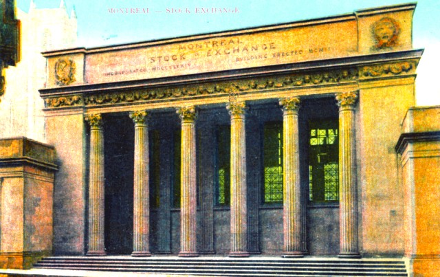
The first stock issued in Montreal was in 1832: 50,000 British pounds of equity in the Champlain and St. Lawrence Railroad.
This was done through a stock book opened in the Montreal Exchange Coffee House.
The Montreal Stock Exchange was incorporated in 1874 ... as the building confirms.
The building was erected in 1902 and the towers of Notre Dame can be seen at the left top corner of the postcard.
The card was sent to Lansdowne, Ontario in August 1911.
"Dear Papa,... It is a good place to lose $100 . As you have some experience in this line"
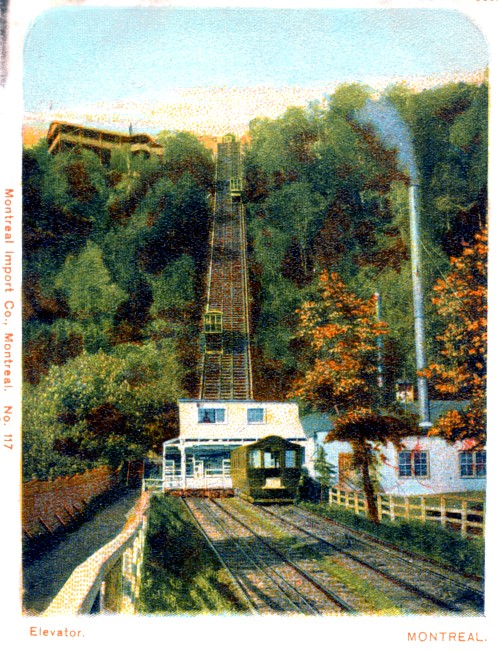
... putting the 'fun' in funicular railway ...
When the Mount Royal park was designed, the recreational ideal was to isolate the summit from the hustle and bustle of the city.
However, we can never have too much progress ... and instead of taking the specially designed winding paths and trails to the top ...
between 1885 and 1918 this two-stage cable incline railway operated on the 'east' end of the mountain.
The railway ran from the intersection of Park Avenue and Duluth Avenue (it 'extended' the latter up the mountain).
As you can see, the railway started on a low gradient ... then passengers transferred to the specialized cars necessary for the final climb to the summit.
Deemed unsafe after the Great War, it was replaced with a necessarily circuitous (to reduce the gradient) streetcar route.
Generally, funicular cars are paired ... think of 'flossing' the back of your neck with a necktie.
and their shared cable turns around a powered capstan at the top ... unless you're an owl, my poor analogy breaks down.
Having the up and down loads balanced requires less power.
I have no idea:
Did a coal-fired generating station (right) power electric motors which turned the capstans for the two sections of track?
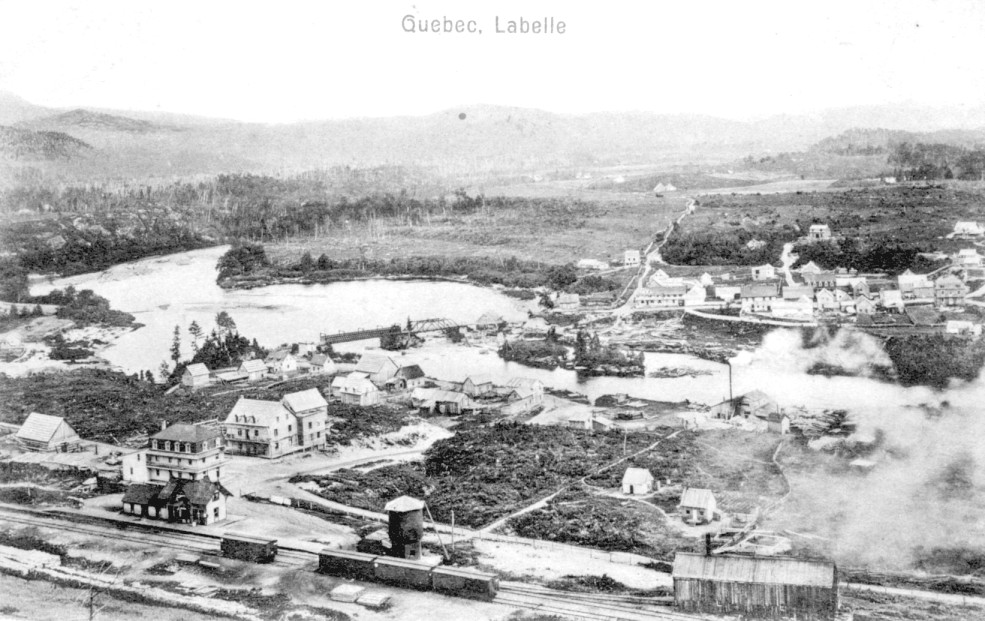
Labelle, Quebec.
The track to the left leads to Montreal. Right leads, or when completed it will lead, to Mont Laurier.
My grandfather retired to a cabin just south of Mont Laurier in the 1960s and we drove through Labelle to visit.
Along the track you can see the station ; the heated water tank ;
a hand-powered derrick for replenishing wood or coal up to the locomotive tenders ;
and an enginehouse (with the stack).
Cordwood and untreated ties are stacked at the lower left.
The sawmill is producing smoke from burning wood waste.
A covered bridge under construction provides the first span across the Rouge River.
The river flows to the photo's left on its way to the Ottawa River near Grenville, Quebec.
Lieutenant Colonel D.E. MacIntyre,
DSO MC, was born in Montreal in 1885. He worked for the CPR, joined the
Army in 1914, managed furniture factories in Ontario, and also had a
real estate business. He wrote about his early experiences as a prairie
storekeeper, about Canada at Vimy, and in "End of Steel" writes about
his work during the location of the railway line between Labelle and
Mont Laurier.
" Twenty miles north of Labelle lay
new country with few farms, that is, much of it was still government
land and was open for homesteading. It was all forest land, and lumber
companies had been taking mostly pine out of it for years. Now the
Quebec government was anxious to fill it with settlers, just as the
Dominion government was filling the West with settlers, but with this
difference: in the West, a man from any nation or any part of Canada
could file on 160 acres of free land, but in Quebec the provincial
government wanted only its own people from the older settled districts
and ex-Canadians from the New England states. These were sure to be
almost entirely French-speaking settlers. In this way the government of
Quebec kept its own people at home and ensured the preservation of
their language and religion. The bait was one hundred acres of free
land.
" In order to provide transportation for the people of Quebec who wished to settle in the Laurentian hills north of Montreal, a line called the Montreal and Western was built as far as Labelle, one hundred miles distant. This line was leased to the Canadian Pacific Railway in 1890, and in 1897 was purchased by that company and called the Labelle branch.
" In 1899 a new company called Le chemin de fer de colonisation du Nord (Northern Colonization Railway) with Senator JB Rolland as its president, was formed for the purpose of extending the line from Labelle to Mont Laurier. However, this new company never built or operated one yard of the line. In 1902 the CPR, from its northern terminus at Labelle and on an understanding with the NCR, began the construction of the twenty-one mile extension to Lake Nominingue, which was completed in 1904 when the CPR leased it from the NCR for a period of 999 years ; in other words, in perpetuity. The line was again extended to its present terminus at Mont Laurier a few years later."
Originally the future settlement of 'Labelle' was named Chute aux Iroquois
because that First Nation(s) sometimes raided that far north, stopping at the
waterfalls. French pioneers shortened the name to 'Lachute' which
confused it with another settlement already using that name - mentioned later on this page. Eventually
the government named it Labelle after the Catholic clergyman who was a
key advocate of this railway and settlement project.
MacIntyre continues:
" When a gang of rivermen hit a town like Labelle after being confined
to a camp in the woods for five months, and with their winter's pay
unspent, they cast aside all restraint and went on a wild spree. They
drank raw whiskey blanc; so
arguments led to fights, and the battles that followed raged all over
the hotel and out on to the street. They used no weapons such as knives
or revolvers like the wild westerners in the States, but made deadly
use of their spiked boots as well as their fists. The Marquis of
Queensberry rules were unknown. If a man was floored by a blow, they
considered that that was the best time to attack him with their spiked
feet ... In some hotels the managers forbade the wearing of spiked
boots, not from any humanitarian motives but to prevent their floors
from being ripped up. Some were kind enough to provide cheap carpet
slippers at the door ...
" One day I saw a man plunk down his winter's pay-cheque and say to the bartender 'Tell me when to stop.' Then he started in to break the big mirror behind the bar by throwing heavy glasses at it. Another man satisfied his urge for destruction by taking the piano stool by the legs and smashing all the keys off the piano ...
" At last, Labelle's Hotel du Nord burned down one night. The whole gang, friends and foes, disregarding everything else, saved the long bar and as much liquor as possible and carried it all across the covered bridge to an empty barn, where business was resumed with lightning-like rapidity."
Behind every successful lumberjack there is a hand rocking the berceau and ruling the world.
* * *
Quebec 1950s/1960s culture sampler (available on iTunes) for this Labelle section.
Le grand six pieds
by Claude Gauthier
... about a lumberjack who solves his prickly labour relations problems with a dishonest 'patron anglais'.
Gauthier is from Lac Saguay where my grandfather lived ...
and the song's action takes place in the surroundings of Lac Saguay.
Le train du nord
by Félix Leclerc
Without understanding a word of French,
you can understand Leclerc's agony of riding
the Mont Laurier-bound 'all stops local' from his music.
The Quebec Grammies are named after 'Félix' - this is the more musical song of the two.
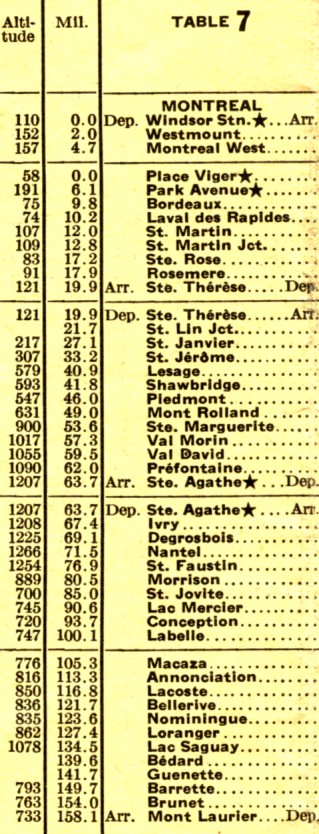
Below is a 1936 public timetable list of stations on the 'Labelle line'.
Using the altitude and mileage, why not spend a pleasurable evening graphing a subdivision profile?
Leclerc sings about 'Ste-Adele' which is at Mont-Rolland mi 49.
For my cousin ...
Sixteen Island Lake
a lumber centre, a vacation spot,
and its railway.
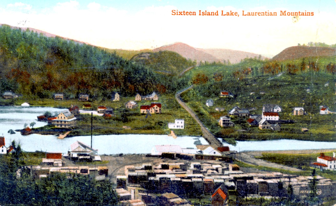
Sixteen Island Lake.
Sawmill, lumber, and boxcars for loading on the far side of the lumber.
About 24 kilometres west of Saint Sauveur, Quebec is Sixteen Island Lake ... or Lac-des-Seize-Îles on Google Earth. The lake is about 6 kilometres long but very irregular in width and shape.
Between the CPR line to Labelle and Sixteen Island Lake was an orphanage set up in 1883 by "La Société de Colonization". Of course Father Labelle was involved with this. The site was named Montfort. A religious community from France (Les Montfortains), a local priest, and seven Soeurs de la Sagesse (nuns) came to operate the orphanage for 200 children. A light 3 foot gauge railway was built to connect Montfort with the standard gauge CPR, Montreal to Labelle line.
A relative of my cousin (and of me), Joseph C. Rodger, moved here from near Granby, Quebec to start up his second sawmill operation around 1893. His Scottish father had settled in Lachute 60 years earlier and Joseph also married a woman from Lachute. The railway line was extended from Montfort to Sixteen Island Lake in 1895 to pick up the lumber cut by Joseph Rodger's mill. In 1898, the company was renamed the Montfort and Gatineau Colonization Railway Company and the track was converted to standard gauge. Eventually it became part of the CNR and the line was finally abandoned in 1962.
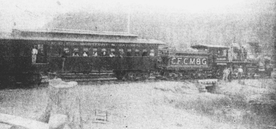
As early photos of this line do not seem to exist elsewhere, here is a highly tuned-up (by me) photo from a local history of the community. The wooden combination coach is probably lit with kerosene lamps. The locomotive tender is filled with wood for fuel. A large spark arrester (screen) sits atop the diamond smokestack. A number of people are posed on the locomotive pilot and running board.
Between the CPR line to Labelle and Sixteen Island Lake was an orphanage set up in 1883 by "La Société de Colonization". Of course Father Labelle was involved with this. The site was named Montfort. A religious community from France (Les Montfortains), a local priest, and seven Soeurs de la Sagesse (nuns) came to operate the orphanage for 200 children. A light 3 foot gauge railway was built to connect Montfort with the standard gauge CPR, Montreal to Labelle line.
A relative of my cousin (and of me), Joseph C. Rodger, moved here from near Granby, Quebec to start up his second sawmill operation around 1893. His Scottish father had settled in Lachute 60 years earlier and Joseph also married a woman from Lachute. The railway line was extended from Montfort to Sixteen Island Lake in 1895 to pick up the lumber cut by Joseph Rodger's mill. In 1898, the company was renamed the Montfort and Gatineau Colonization Railway Company and the track was converted to standard gauge. Eventually it became part of the CNR and the line was finally abandoned in 1962.
As early photos of this line do not seem to exist elsewhere, here is a highly tuned-up (by me) photo from a local history of the community. The wooden combination coach is probably lit with kerosene lamps. The locomotive tender is filled with wood for fuel. A large spark arrester (screen) sits atop the diamond smokestack. A number of people are posed on the locomotive pilot and running board.
From Beloved Over All - The Story of Sixteen Island Lake, by K.Gilbert Cook 1986
Joseph Rodger continued sawing away until until 1905 when he retired at
the age of 75. His second house was quite large, changed hands, and
eventually became a hotel named "The Manor House".
In addition to the lumber activity, the railway connection provided 'convenient' access for cottagers and other recreational visitors ... about 3 1/2 hours from Montreal after changing trains at Montfort Junction ... covering 90 kilometres in all. As the working week for most was 5.5 to 6 days per week without today's 2 day weekend, Montreal workers could generally only come here for vacation.
However, people from Lachute and other closer settlements had quicker access to the cottages, lodges and hotels on the lake. Fishing, boating and 'regattas' were popular activities here. Water transportation was more direct and simpler than trying to negotiate forest trails between cottages, hotels, churches, and stores - when the trails existed at all.
This postcard was rerouted from Montreal to Weymouth, Nova Scotia.
"Having a fine time up here. We go to church by boat."
Travelling between Montreal and Ottawa
on the Ottawa River
An upbound trip ...
" At Carillon the steamer's course is once more barred by rapids, to
avoid which a canal has been constructed ; but passengers by the
mail-boat land at Carillon and take [the] train to Grenville, a distance of
twelve miles, whence another steamer proceeds without farther
interruption to Ottawa. Opposite Carillon, at Point Fortune, the river
becomes the boundary line between the two Provinces. At the Chute au
Blondeau is another canal an eighth of a mile in length and a dam has
here been thrown across the river, which so pens back the waters that
only a passage of three-quarters of a mile in length is now needed to
reach the higher level above the chute. Beside the Long Sault Rapid is
the Grenville Canal, excavated for the most part through solid rock,
and leading to the village of Grenville, a distance of six miles. These
three canals were constructed, like that of the Rideau, by the Imperial
Government for military purposes. Happily, there is no prospect of
their being needed for such ; and even should necessity arise,
their usefulness is a thing of the past, superseded, as they now are,
by the opening of the St. Lawrence Canals and the Grand Trunk Railway
on the front, as well as by the new lines of railway to the north,
which make our intercommunication secure from any foe. Down these three
rapids - the Carillon, Long Sault, and Chute au Blondeau - the
lumbermen descend on their cribs of timber. Formidable as this feat
looks, it is frequently accomplished by travellers who adventure in
company with the raftsmen, and seldom suffer worse consequences than a
wetting."
from
Picturesque Canada ; The country as it was and is
George Monro Grant, Queen's University
Travelling up the Ottawa ...
Ste. Annes Lock
Length 1/2 mile, one lock 200 x 45 feet, 9 feet of water on the sills.
Old lock still available 200 x 45 feet, 6 feet of water on the sills.
Carillon Canal
Length 3/4 mile, two locks 200 x 45 feet, 9 feet of water on the sills, total rise 16 feet.
Grenville Canal
Length 5 3/4 miles, five locks 200 x 45 feet, 9 feet of water on the sills, total rise 43 3/4 feet.
from
Railways and Canals Report, Canada 1913.
Note: The canal at Chute au Blondeau was mainly a 'water source' for the Carillon Canal.
It tapped the extra 'higher' water from the nearby North River and was not itself used by boats travelling between Ottawa and Montreal.
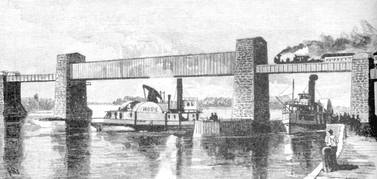
Near the lock at Ste Anne de Bellevue at the west end of Montreal Island.
The "Hope" is paddling up the Ottawa River.
The steamship coming toward us is finishing its cruise down the Ottawa and
is about to enter the St. Lawrence River to complete its journey to Montreal.
The Grand Trunk train is travelling toward Toronto.
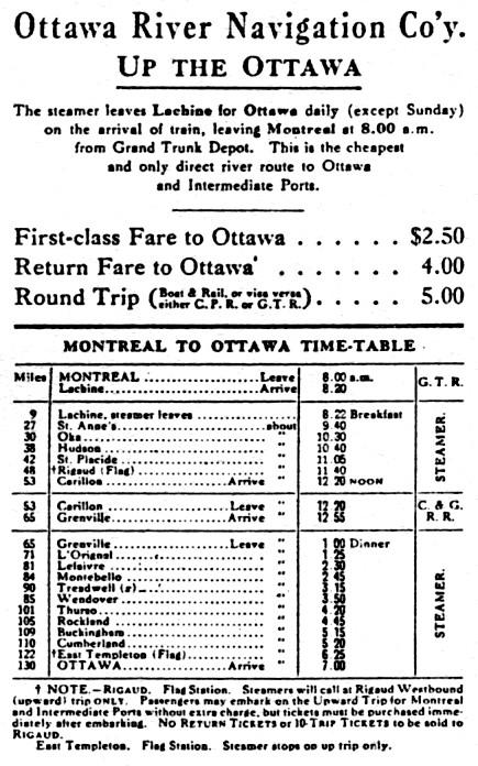
A 1910 railway to steamship to railway to steamship schedule.
This was the last year of the Carillon and Grenville's operation.
Details of the early history of these canals are not available ...
The Grenville Canal lies on the
north shore of the Ottawa, and carries navigation around the 'Long
Sault Rapids'. It is excavated partly through solid rock and partly
through earth ; the locks are of cut stone. It was designed and
commenced by the Royal Staff Corps, for the Imperial Government, in
1819 ; but owing to the limited amount appropriated to this work each
year its progress was very slow. As in the Carillon and Chute au
Blondeau canals, the original designs contemplated locks corresponding
in size to the Lachine Canal.
Three of the locks were commenced and completed on these dimensions; but in 1828, the enlarged scale of the Rideau locks was adopted for the four remaining.
All records relating to the establishment of these three canals - the Carillon, Chute au Blondeau and the Grenville - were kept in the Ordnance office in Montreal, and were destroyed by fire in 1849. It appears, however, from information given by parties engaged in the construction of the works, that the Grenville canal was completed in 1829 the Chute au Blondeau in 1832, and the Carillon in 1833; and, further that on the 24th of April, 1834, the canals were opened, and the steamer 'St. Andrews' with two barges in tow, made the first passage through them.
These canals were transferred to the Canadian Government about forty years ago, [i.e. circa 1854] and since that time their capacity has been greatly enlarged.
Letter for C. Thomas.
* * *
The origin of the Carillon and Grenville Railway - which was routed around BOTH the Carillon and Grenville canals ...
The Carillon & Grenville
Railway is only a section of a road which was to be built from Montreal
to Ottawa ; and though it commenced with a fair prospect of success, it
ended disastrously for its projectors.
It was begun in 1857 by two brothers from England, William and Samuel Sikes [actually 'Sykes'], both skillful mechanics, and one, at least, being a mechanical engineer. The money for the enterprise was to be provided by an English banking firm, Sikes, DeBerg & Co., of which firm, Alexander Sikes, a brother of the two named above, was a member.
Labor on the road was commenced at different points, Montreal, St. Eustache, St. Andrews, etc., a steam mill being erected at the latter place, near the River Rouge, to saw lumber required in the construction of the road, and artesian wells were sunk to provide the mill with water.
The work had progressed favorably for nearly two years - the men employed had been promptly paid, and the money to pay the last sum of indebtedness for labor had been sent from England, when a sad accident abruptly terminated the whole project.
Immediately after the last installment of money had been sent, Alexander Sikes took passage on a vessel for America, with a view, it is supposed, of inspecting the work in which his company had invested so much money ; but the vessel, with all on board, was lost. When this sad accident became known in England, the company of which the deceased, Mr. Sikes, had been a member sent to their representative here, requesting him to return the money he had lately received.
The order was obeyed, and thus the Sikes brothers on this side of the Atlantic were without means to accomplish their object. Unwilling, however, to abandon the work, they invested what little capital they possessed, which being soon swallowed up, the work, from necessity, was abandoned.
Others besides the Sikes brothers lost heavily in this unlucky venture, none, perhaps, more largely than Sydney Bellingham, MPP for Argenteuil.
The only completed portion of the road was that between Carillon and Grenville, and this coming into possession of the late Hon. JJC Abbott, solicitor for its managers, was, by him sold to the Ottawa River Navigation Company in 1863.
from
History of the Counties of Argenteuil Que and Prescott Ont
Cyrus Thomas, 1896
This work is an interesting combination of local history, social register, advertisement and gossip.
There are other versions of the early development of the C&G.
History of the Counties of Argenteuil Que and Prescott Ont
Cyrus Thomas, 1896
This work is an interesting combination of local history, social register, advertisement and gossip.
There are other versions of the early development of the C&G.
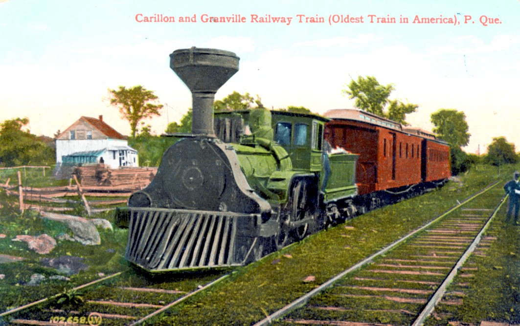
Built in Britain in the 1850s for
the Grand Trunk Railway of Canada, the three or so locomotives the
C&G used through the years were kept running by a British master
mechanic who also served as the locomotive engineer ... for much of the
railway's existence. Periodic visits were made to the Grand Trunk shops
at Point St. Charles to scavenge parts.
The locomotive 'wheel arrangement' (the number of driving and unpowered wheels) of the original locomotives had been altered ... but the gauge of the C&G engines was still their original 'Provincial Gauge' at 5 feet 6 inches ... 17% wider than the Standard Gauge used almost everywhere else then and now.
The original reason for Provincial Gauge legislation was to make American invasion of Canada inconvenient. By the late 1800s invasion seemed unlikely, so Standard Gauge was adopted to facilitate commerce between the two countries.
Some railroaders in America have suggested that for capacity and stability, Standard Gauge is too narrow ... in hindsight.
Bridging between the two stretches
of smooth sailing for steamships ... Montreal-Carillon and
Grenville-Ottawa ... the little antiques of the Carillon and Grenville
Railway faithfully trundled back and forth from 1854 to 1910. By the latter
date, through railway lines between Montreal and Ottawa had diverted
most of the river and portage traffic on which the C&G had
depended.
This postcard was postmarked July 2, 1909 at Grenville, and mailed to Bishops Mills, Ontario. The writer was likely on the trip for a vacation during this second to last year of the railway's operation.
This postcard was postmarked July 2, 1909 at Grenville, and mailed to Bishops Mills, Ontario. The writer was likely on the trip for a vacation during this second to last year of the railway's operation.
" We had a beautiful trip from
Ottawa on the Str 'Duchess of York' ... The old train you see is only a
short-line. We have also the CPR and Canada Northern [sic]. The
rapids are exciting ... People are very nice and kind. Write me soon
and tell me all about Sharbot Lake."
Captured on this colourized postcard ...
the little Birkenhead locomotive will simmer on the passing track forever ...
the conductor eternally checking his paperwork ... the engine crewman always leaning back on the tender ...
with the scents of wildflowers, fresh hay, and the locomotive's wood smoke blending in the warm summer breeze.
the little Birkenhead locomotive will simmer on the passing track forever ...
the conductor eternally checking his paperwork ... the engine crewman always leaning back on the tender ...
with the scents of wildflowers, fresh hay, and the locomotive's wood smoke blending in the warm summer breeze.
Back to Sitemap