Vacationing in Nova Scotia and Cape Breton in 1980
As two new hospital employees, very low on the seniority list, we often requested vacation in the fall.
Our cars were not air-conditioned until the 21st Century, due to some strange conviction that it would 'make a difference' for the environment. Another benefit of travelling in Canada in the fall was that the roads and museums were not crowded. The first of our 'Canada by land' vacations was to Quebec, New Brunswick, Nova Scotia (including Cape Breton and the Cabot Trail), and Prince Edward Island.
We spent most of our time in Nova Scotia. During our week or so in that province, we toured around most of Nova Scotia's seashore : Halifax to Lunenburg and Yarmouth; Yarmouth to the Bay of Fundy; and back to Halifax. Then we went all along the Atlantic Ocean seashore east of Halifax - kind of, um, a slow road with little to see in those days - then across to Cape Breton.
This is not a comprehensive travelogue. However, some interesting contrasts come to mind when looking back.
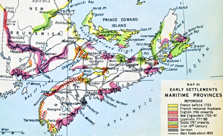
I am quite relieved to present this map ... rather than trying to explain in words the recent human history it represents. The history of settlement of the Maritime Provinces after the First Nations is full of brave starts and a few reversals.
Our cars were not air-conditioned until the 21st Century, due to some strange conviction that it would 'make a difference' for the environment. Another benefit of travelling in Canada in the fall was that the roads and museums were not crowded. The first of our 'Canada by land' vacations was to Quebec, New Brunswick, Nova Scotia (including Cape Breton and the Cabot Trail), and Prince Edward Island.
We spent most of our time in Nova Scotia. During our week or so in that province, we toured around most of Nova Scotia's seashore : Halifax to Lunenburg and Yarmouth; Yarmouth to the Bay of Fundy; and back to Halifax. Then we went all along the Atlantic Ocean seashore east of Halifax - kind of, um, a slow road with little to see in those days - then across to Cape Breton.
This is not a comprehensive travelogue. However, some interesting contrasts come to mind when looking back.
I am quite relieved to present this map ... rather than trying to explain in words the recent human history it represents. The history of settlement of the Maritime Provinces after the First Nations is full of brave starts and a few reversals.
Another key aspect of Nova Scotia in particular is ... the importance of the sea ... argh, matey!
On the map above, you'll notice that the pre-Confederation settlements are almost all along the seashore or along rivers.
On the map above, you'll notice that the pre-Confederation settlements are almost all along the seashore or along rivers.
The sea was a source of food for
sustenance and commerce. It often provided the most practical method of
transportation. In turn, fishing and sea travel drove the development
of an active local shipbuilding industry which specialized in wood and
sail technology ... and is commemorated by the 'Bluenose-like' schooner
on the Canadian dime.
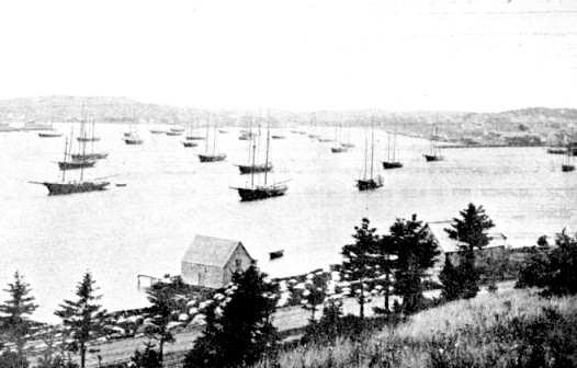
Lunenburg harbour circa 1900.
The sea was also the bearer of successive waves of military invaders.
Most of the human conflict in the area involved amphibious attacks.
Most of the human conflict in the area involved amphibious attacks.
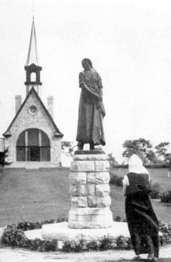
A statue of a fictitious Acadian resident in front of a replica Acadian church - Longfellow's Evangeline.
In 1755, Acadian-born farm families were scattered far and wide at the point of a bayonet and by the power of sail.
Halifax and the Atlantic
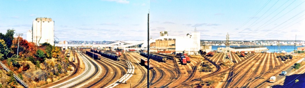
This is what the CNR yards looked
like at Halifax in 1980. The passenger station is somewhere at the end
of that light grey ballast at the left. A radio aerial on a pole is my convenient
photo-stitching divider.
Halifax has a long history as a seaport because its harbour is wide in most places and well-sheltered. It was important as the exporting point for much of Canada's agricultural and mineral production when trade links with Imperial Britain were strong. It was also a key point of immigration when people still travelled across the ocean by ship, rather than airplane.
Along with the excellent natural harbours of Sydney (Cape Breton) and St. John's (Newfoundland) ... Halifax's harbour was used to 'form up' Allied convoys of ships carrying food, fuel and war materiel across the Atlantic during the two world wars. All types of freighters were pressed into wartime service and convoys had military escorts, but they only travelled at the speed of the slowest ship - often around 10 knots. With German U-boats active in Canadian waters, supplies were taken as far east as they could travel by rail - Halifax - and then ran the gauntlet across the Atlantic. This meant that the capacity of the CNR Montreal to Halifax railway line, and the efficiency of the port itself had a major impact on the tempo of convoy operations.
If large, fast, modern passenger liners were used as troop ships the safest course was to make a run for it alone, often using an irregular zig-zag course. U-boats could not out-run modern liners, but they could radio ahead so other German submarines could intercept and sink the troop transports.
As you can imagine, very efficient choreography of passenger cars, locomotives, crews and all the other traffic was necessary to ensure that a stripped-of-all-luxury passenger liner was quickly packed full of soldiers. Multiple trains (ten is an approximate number) were needed to load a single ship.
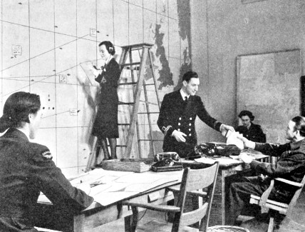
A Royal Canadian Navy and Royal Canadian Air Force convoy operations room.
Convoy positions and U-boat sightings would be plotted.
As World War 2 continued, German U-boat crews faced much higher mortality rates as convoy support weapons and tactics improved.
Although constrained by the range of the aircraft and weather, depth charges delivered by aircraft made U-boat work especially difficult.
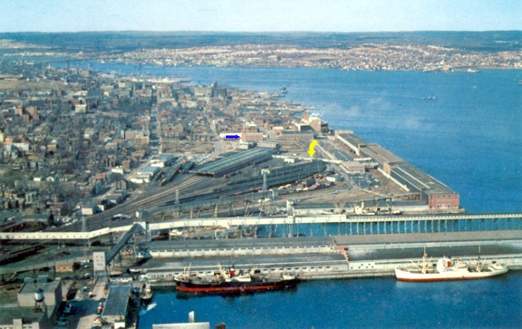
From the 1960s, this postcard of Halifax shows the passenger train sheds at the centre of the photo.
They end at the station. Just beyond the station is the local CNR railway hotel (blue arrow, shown next).
A little closer to the camera are long lines of waiting passenger coaches in the nearby coachyard.
Still at the centre of the photo ...
I believe the thin white enclosed walkway (yellow arrow)
leads from the train sheds, behind the coachyard, to the famous Pier 21 ...
which is now a Canadian immigration museum.
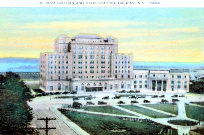
This postcard was probably printed when the CNR hotel was new in 1928 or 1929.
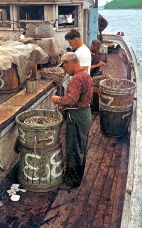
In contrast to the patrons of the Nova Scotian,
three Lunenburg fishermen prepare lines for another trip out on the dory schooner 'Theresa E Connor'.
The ship was launched in 1938 and owned by the Maritime National Fish Co.
It was retired in 1967.
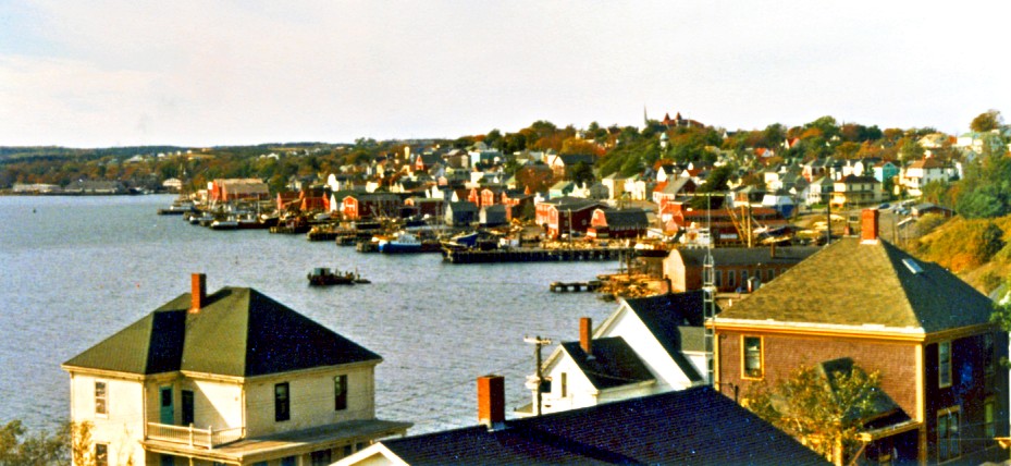
Lunenburg as we saw it in 1980.
A map is following to show some of these locations.
The Bay of Fundy
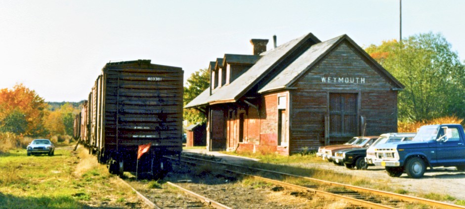
Weymouth station of the Dominion Atlantic Railway in 1980 - owned by the CPR.
A 1945 timetable below shows the scheduled passenger trains and their connection with the Digby (Nova Scotia) to Saint John (New Brunswick) CPR ferry.
The CPR did not have its own rails running continuously into Nova Scotia - the CPR Bay of Fundy ferry provided the connection.
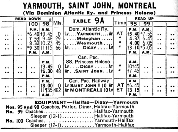
1945 CPR passenger timetable
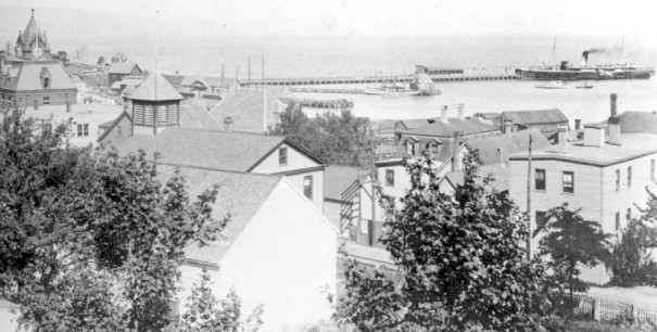
Digby, Nova Scotia in 1906
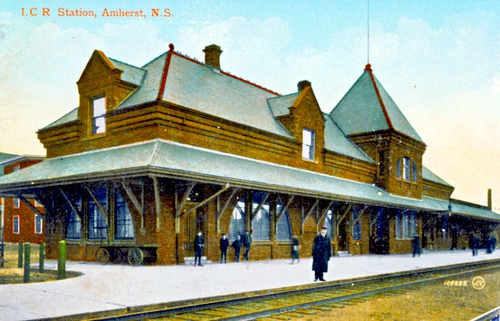
In contrast to the charming, informal station of the CPR at Weymouth ...
here is the 'all business' station of the Intercolonial Railway (later CNR) at Amherst, circa 1910.
This was the main railway line connecting Halifax with the rest of Canada - a critical link during the wars.
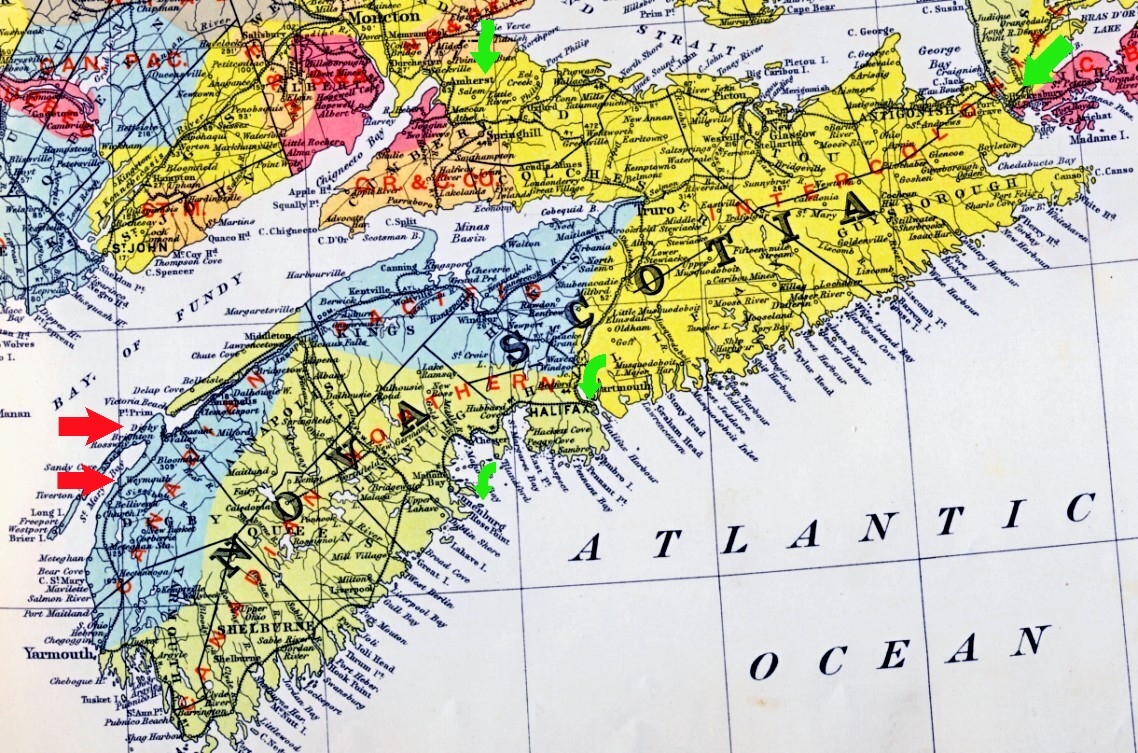
This 1911-1915 map shows the 'railway territories' as defined by legislation
and the regulations of the Board of Railway Commissioners.
The CPR (blue territory) was along the Fundy shore.
Red arrows show Weymouth and Digby.
The Canadian Northern (olive-brown) was mainly along the Atlantic shore.
The Intercolonial (gold) came through from Moncton to Truro ...
where two lines led to either Halifax or Cape Breton.
The Canadian Northern and Intercolonial eventually became parts of the CNR.
Green arrows show Halifax and Lunenburg, Amherst, and the connection with Cape Breton.
The Canso Causeway to Cape Breton
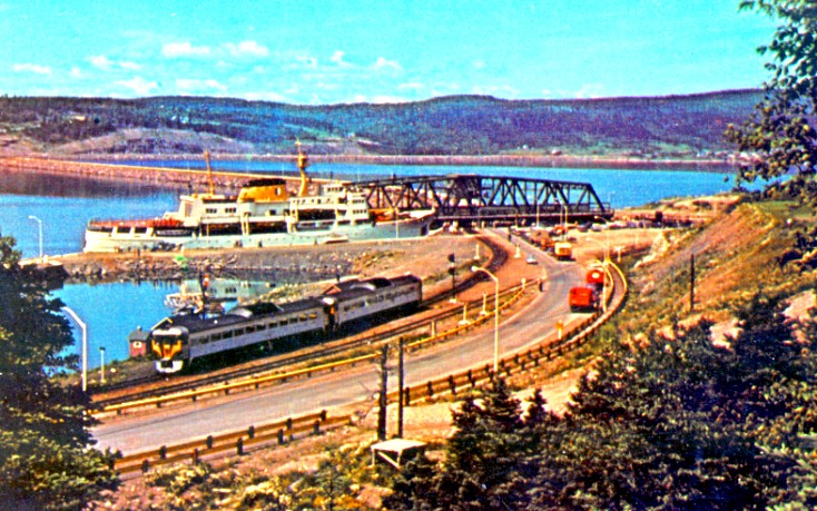
Completed in 1955, the Canso Causeway spanned the gap between Cape Breton and mainland Nova Scotia.
Probably from around 1960, this postcard is taken from the Cape Breton side.
Halifax bound CNR rail diesel cars (a passenger train) and highway traffic wait
while the government survey ship 'Baffin' passes through the lock.
The lock is necessary because two tidal zones were created by the artificial blockage of the strait ...
at times during the day when these two tidal zones weren't equalized ...
water travelling through this little canal would otherwise be moving pretty quickly!
After the 'Baffin' passes, the swing bridge will align across the short canal so the land traffic can continue.
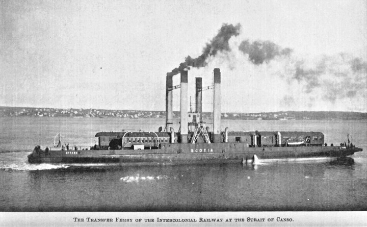
In contrast to the Causeway, here is how land traffic crossed the Strait of Canso for over half a century.
A series of coal-powered 'car ferries' were used to carry Intercolonial Railway and later CNR traffic
between Cape Breton's railway system ... and the rail systems operating across North America.
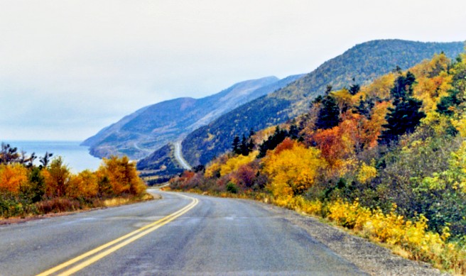
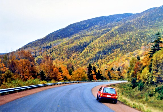
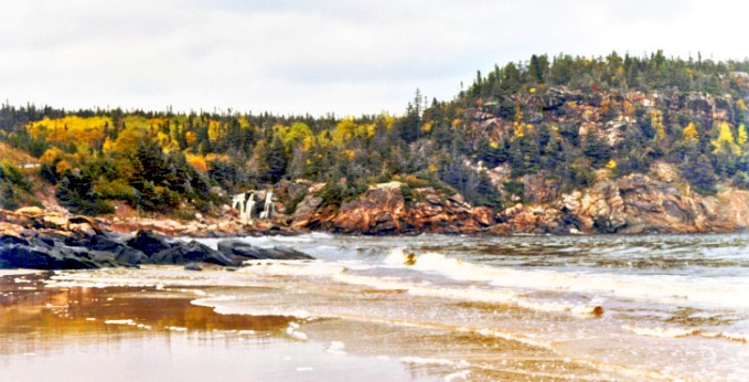
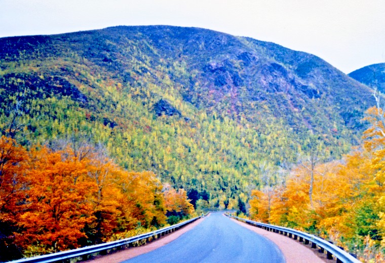
On the Cabot Trail
The benefits of an autumn
vacation
are evident in the following photographs. First, there are no
heavily-laden, underpowered 'camper' vehicles to drive behind. The fall
foliage
is quite nice. Finally, the trail is so deserted that it was apparently
safe to stand or park in the middle of the road to get just the right
photograph.
The Sydney Area
Once we reached Sydney, we were back to civilization.
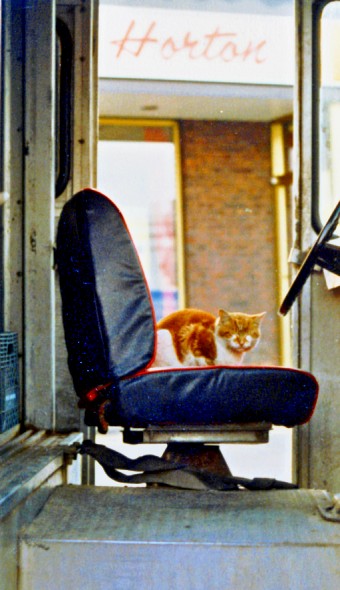
Here is a milk truck sentry cat at The Horton's.
What is the difference between
a working Sydney milk truck sentry cat ...
and a working Thunder Bay railway yard sentry cat ?
... a tail.
(true story)
* * *
On the 1911-1915 map of Cape Breton below, the railway territories are again shown - four of them.
The large blue arrow approximately shows the point where the Cabot Trail crosses over to the eastern shore.
We continued south and then east to arrive in Sydney.
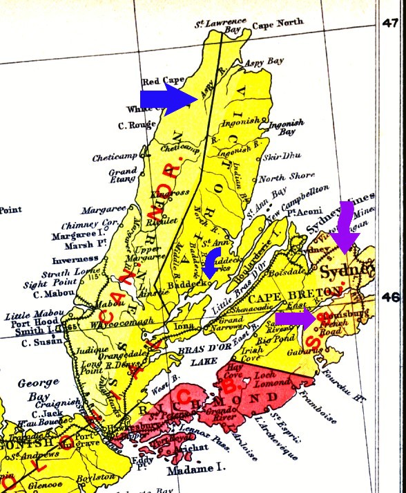
The small blue arrow shows Baddeck on the Bras d'Or Lakes (saltwater).
Baddeck was the site of the first powered flight in Canada in 1909, supported by Alexander Graham Bell ... who also lived there.
Sydney is central to the next page ... on iron melting and bashing on Cape Breton.
Louisbourg (purple arrow) was the location of the massive, ill-fated French fortress.
Louisbourg's importance 'At the front door of Canada' was begun by the French.
It's value as an ice-free port is further illustrated by the Sydney and Louisburg Railway ...
the shortline built to reliably export the products of Sydney's 20th Century heavy industry.
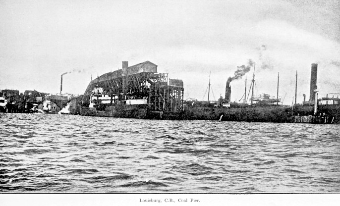
Louisburg ... the ice-free port, circa 1910
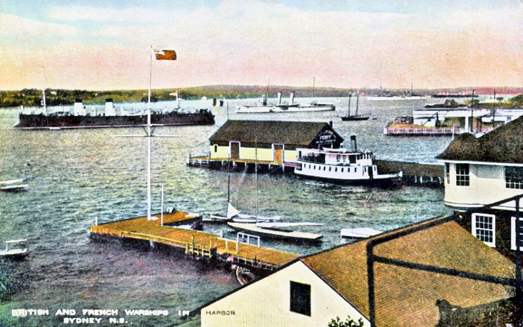
Part of Sydney Harbour, circa 1915
All of a sudden, the French and British are getting along ...